Poconé geodata
Poconé (Mato Grosso) is a populated place; located in Brazil in America/Cuiaba (GMT-4) time zone. With population of 21,484 people, there are 887 cities with bigger population in this country. Compared to other cities in Brazil, 52.9% of cities are located further ↓South; 96.1% of cities are located further →East and 67.3% of cities have higher elevation than Poconé. Note1


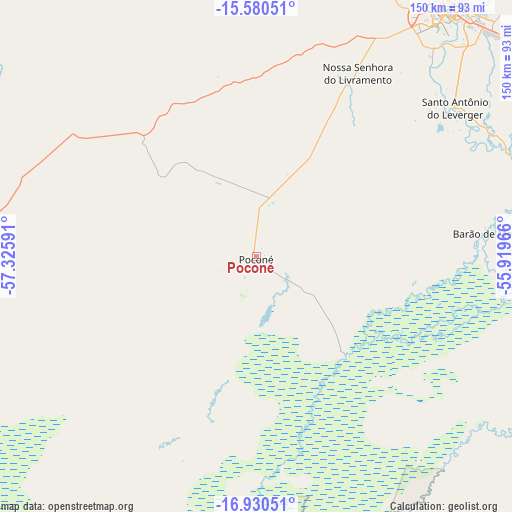
Poconé GPS coordinates[2]
16° 15' 24.012" South, 56° 37' 22.008" West
| Map corner | latitude | longitude |
|---|---|---|
| Upper-left | -15.58051°, | -57.32591° |
| Center: | -16.25667°, | -56.62278° |
| Lower-right: | -16.93051°, | -55.91966° |
| Map W x H: | 150.1×150.1 km | = 93.3×93.3mi |
| max Lat: | 2.81972° ⇑47.1% North |
| Poconé: | -16.25667° |
| min Lat: | ⇓52.9% South -33.69111° |
| min Long | Poconé | max Long |
| -72.89583° | -56.62278° | -32.41083° |
| W 3.9%⇐ | ⇒96.1% E |
Elevation
Elevation of Poconé is 150 m = 492 ft, and this is 230.9 m = 758 ft below average elevation for this country.
| Max E: |
1603 m = 5259 ft | 67.3% |
| Avg. | 380.9 m = 1250 ft | |
| Poconé | 150 m = 492 ft | |
Min E: |
0 m = 0 ft | 32.7% |
See also: Brazil elevation on elevation.city.
Geographical zone
Poconé is located in South Torrid zone (between Equator and Tropic of Capricorn). Distance of this Southern Tropic circle is 798.3 km =496 mi to South.| Distance of | km | miles | from Poconé |
|---|---|---|---|
| Equator | 1807.6 | 1123.2 | to North |
| Tropic Capricorn | 798.3 | 496 | to South |
| Antarctic Circle | 5593.6 | 3475.7 | to South |
| South Pole | 8199.5 | 5094.9 | to South |


Nearby cities:
15 places around Poconé: (largest is in red/bold)
• Arenápolis
202.3 km =125.7 mi,  353°
353°
• Barra do Bugres
144.6 km =89.9 mi,  335°
335°
• Barão de Melgaço
70.3 km =43.7 mi,  84°
84°
• Chapada dos Guimarães
128.7 km =80 mi,  46°
46°
• Cuiabá
92.5 km =57.5 mi,  37°
37°
• Diamantino
206.4 km =128.3 mi,  5°
5°
• Jaciara
179.7 km =111.7 mi, 79°
• Lucas
74.1 km =46 mi,  96°
96°
• Nobres
173.7 km =107.9 mi, 10°
• Nortelândia
201.3 km =125.1 mi, 354°
• Nova Olímpia
177.2 km =110.1 mi, 336°
• Rondonópolis
213.3 km =132.5 mi, 96°
• Rosário Oeste
159.3 km =99 mi, 7°
• Santo Antônio do Leverger
72.8 km =45.2 mi, 53°
• Várzea Grande
85.7 km =53.3 mi, 37°
Sources, notices
• [Note1] Compared only with cities in Brazil existing in our database
• [Src1] Map data: © OpenStreetMap contributors (CC-BY-SA)
• [Src2] Other city data from geonames.org with taken over terms of usage.
• [Src3] Geographical zone / Annual Mean Temperature by Robert A. Rohde @ Wikipedia
