Uberaba geodata
Uberaba (Minas Gerais) is a populated place; located in Brazil in America/Sao_Paulo (GMT-3) time zone. With population of 260,843 people, there are 82 cities with bigger population in this country. Compared to other cities in Brazil, 55.5% of cities are located further ↑North; 64.3% of cities are located further →East and 86.8% of cities have lower elevation than Uberaba. Note1


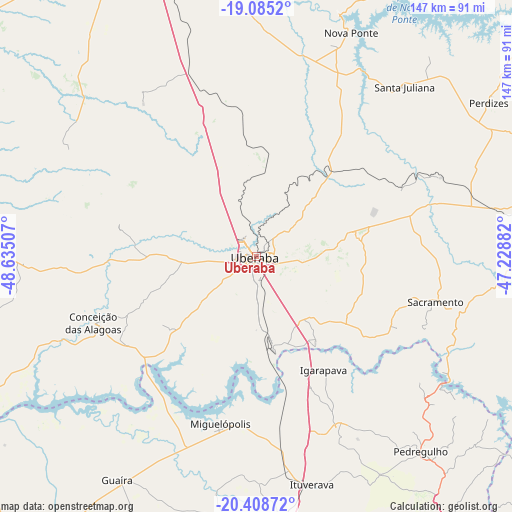
Uberaba GPS coordinates[2]
19° 44' 53.988" South, 47° 55' 54.984" West
| Map corner | latitude | longitude |
|---|---|---|
| Upper-left | -19.0852°, | -48.63507° |
| Center: | -19.74833°, | -47.93194° |
| Lower-right: | -20.40872°, | -47.22882° |
| Map W x H: | 147.2×147.2 km | = 91.5×91.5mi |
| max Lat: | 2.81972° ⇑55.5% North |
| Uberaba: | -19.74833° |
| min Lat: | ⇓44.5% South -33.69111° |
| min Long | Uberaba | max Long |
| -72.89583° | -47.93194° | -32.41083° |
| W 35.7%⇐ | ⇒64.3% E |
Elevation
Elevation of Uberaba is 772 m = 2533 ft, and this is 391.1 m = 1283 ft above average elevation for this country.
| Max E: |
1603 m = 5259 ft | 13.2% |
| Uberaba | 772 m 2533 ft | |
| Avg. | 380.9 m = 1250 ft | |
Min E: |
0 m = 0 ft | 86.8% |
See also: Uberaba elevation on elevation.city.
Geographical zone
Uberaba is located in South Torrid zone (between Equator and Tropic of Capricorn). Distance of this Southern Tropic circle is 410.1 km =254.8 mi to South.| Distance of | km | miles | from Uberaba |
|---|---|---|---|
| Equator | 2195.8 | 1364.4 | to North |
| Tropic Capricorn | 410.1 | 254.8 | to South |
| Antarctic Circle | 5205.4 | 3234.5 | to South |
| South Pole | 7811.3 | 4853.7 | to South |


Nearby cities:
15 places around Uberaba: (largest is in red/bold)
• Araxá
105.2 km =65.4 mi,  80°
80°
• Conceição das Alagoas
51.2 km =31.8 mi,  248°
248°
• Franca
103.9 km =64.6 mi,  147°
147°
• Frutal
109.8 km =68.2 mi, 253°
• Guará
76.4 km =47.5 mi,  171°
171°
• Guaíra
74.7 km =46.4 mi,  211°
211°
• Igarapava
37.6 km =23.4 mi, 149°
• Ipuã
77.1 km =47.9 mi,  186°
186°
• Ituverava
67.6 km =42 mi, 166°
• Miguelópolis
49.1 km =30.5 mi, 192°
• Orlândia
108.2 km =67.2 mi,  177°
177°
• Pedregulho
73.9 km =45.9 mi,  139°
139°
• Sacramento
53.1 km =33 mi,  104°
104°
• São Joaquim da Barra
93 km =57.8 mi, 175°
• Uberlândia
99.1 km =61.6 mi,  338°
338°
Sources, notices
• [Note1] Compared only with cities in Brazil existing in our database
• [Src1] Map data: © OpenStreetMap contributors (CC-BY-SA)
• [Src2] Other city data from geonames.org with taken over terms of usage.
• [Src3] Geographical zone / Annual Mean Temperature by Robert A. Rohde @ Wikipedia
