Itapetinga geodata
Itapetinga (Bahia) is a populated place; located in Brazil in America/Bahia (GMT-3) time zone. With population of 59,721 people, there are 370 cities with bigger population in this country. Compared to other cities in Brazil, 55.6% of cities are located further ↓South; 74.3% of cities are located further ←West and 54.3% of cities have higher elevation than Itapetinga. Note1


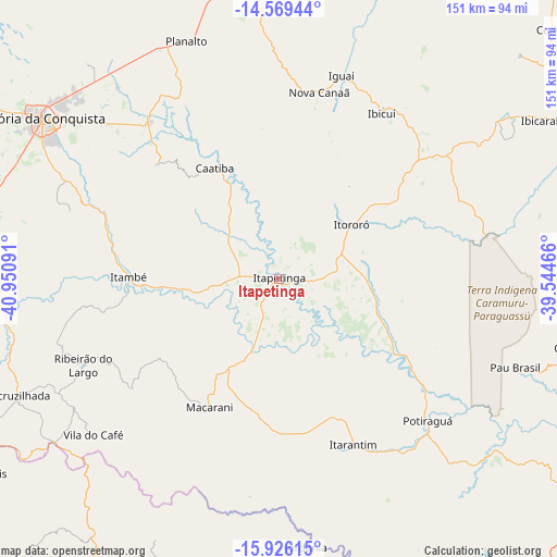
Itapetinga GPS coordinates[2]
15° 14' 56.004" South, 40° 14' 52.008" West
| Map corner | latitude | longitude |
|---|---|---|
| Upper-left | -14.56944°, | -40.95091° |
| Center: | -15.24889°, | -40.24778° |
| Lower-right: | -15.92615°, | -39.54466° |
| Map W x H: | 150.9×150.9 km | = 93.8×93.8mi |
| max Lat: | 2.81972° ⇑44.4% North |
| Itapetinga: | -15.24889° |
| min Lat: | ⇓55.6% South -33.69111° |
| min Long | Itapetinga | max Long |
| -72.89583° | -40.24778° | -32.41083° |
| W 74.3%⇐ | ⇒25.7% E |
Elevation
Elevation of Itapetinga is 282 m = 925 ft, and this is 98.9 m = 324 ft below average elevation for this country.
| Max E: |
1603 m = 5259 ft | 54.3% |
| Avg. | 380.9 m = 1250 ft | |
| Itapetinga | 282 m = 925 ft | |
Min E: |
0 m = 0 ft | 45.7% |
See also: Itapetinga elevation on elevation.city.
Geographical zone
Itapetinga is located in South Torrid zone (between Equator and Tropic of Capricorn). Distance of this Southern Tropic circle is 910.4 km =565.7 mi to South.| Distance of | km | miles | from Itapetinga |
|---|---|---|---|
| Equator | 1695.5 | 1053.5 | to North |
| Tropic Capricorn | 910.4 | 565.7 | to South |
| Antarctic Circle | 5705.7 | 3545.4 | to South |
| South Pole | 8311.5 | 5164.5 | to South |


Nearby cities:
15 places around Itapetinga: (largest is in red/bold)
• Almenara
114.4 km =71.1 mi,  204°
204°
• Buerarema
106.7 km =66.3 mi,  72°
72°
• Coaraci
100.9 km =62.7 mi,  47°
47°
• Encruzilhada
77.6 km =48.2 mi,  246°
246°
• Ibicaraí
82.8 km =51.4 mi,  58°
58°
• Ibicuí
53.3 km =33.1 mi,  31°
31°
• Iguaí
57.3 km =35.6 mi,  17°
17°
• Itajuípe
113.2 km =70.3 mi, 55°
• Itambé
40.4 km =25.1 mi,  270°
270°
• Itarantim
49.7 km =30.9 mi,  156°
156°
• Itororó
24 km =14.9 mi, 52°
• Mascote
107.2 km =66.6 mi,  109°
109°
• Pau Brasil
68.3 km =42.4 mi, 110°
• Poções
81 km =50.3 mi,  351°
351°
• Vitória da Conquista
76.5 km =47.5 mi,  303°
303°
Sources, notices
• [Note1] Compared only with cities in Brazil existing in our database
• [Src1] Map data: © OpenStreetMap contributors (CC-BY-SA)
• [Src2] Other city data from geonames.org with taken over terms of usage.
• [Src3] Geographical zone / Annual Mean Temperature by Robert A. Rohde @ Wikipedia
