Almenara geodata
Almenara (Minas Gerais) is a populated place; located in Brazil in America/Sao_Paulo (GMT-3) time zone. With population of 29,333 people, there are 681 cities with bigger population in this country. Compared to other cities in Brazil, 53.2% of cities are located further ↓South; 71.5% of cities are located further ←West and 61.9% of cities have higher elevation than Almenara. Note1


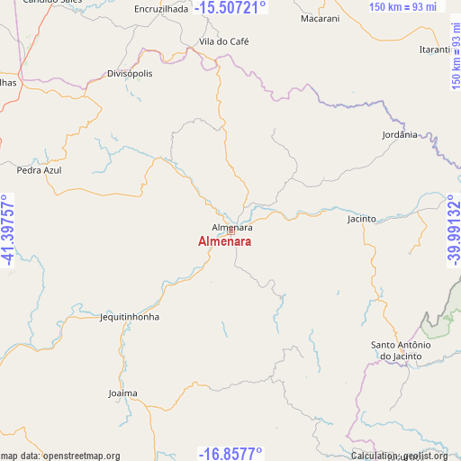
Almenara GPS coordinates[2]
16° 11' 0.996" South, 40° 41' 39.984" West
| Map corner | latitude | longitude |
|---|---|---|
| Upper-left | -15.50721°, | -41.39757° |
| Center: | -16.18361°, | -40.69444° |
| Lower-right: | -16.8577°, | -39.99132° |
| Map W x H: | 150.2×150.2 km | = 93.3×93.3mi |
| max Lat: | 2.81972° ⇑46.8% North |
| Almenara: | -16.18361° |
| min Lat: | ⇓53.2% South -33.69111° |
| min Long | Almenara | max Long |
| -72.89583° | -40.69444° | -32.41083° |
| W 71.5%⇐ | ⇒28.5% E |
Elevation
Elevation of Almenara is 193 m = 633 ft, and this is 187.9 m = 616 ft below average elevation for this country.
| Max E: |
1603 m = 5259 ft | 61.9% |
| Avg. | 380.9 m = 1250 ft | |
| Almenara | 193 m = 633 ft | |
Min E: |
0 m = 0 ft | 38.1% |
See also: Brazil elevation on elevation.city.
Geographical zone
Almenara is located in South Torrid zone (between Equator and Tropic of Capricorn). Distance of this Southern Tropic circle is 806.5 km =501.1 mi to South.| Distance of | km | miles | from Almenara |
|---|---|---|---|
| Equator | 1799.4 | 1118.1 | to North |
| Tropic Capricorn | 806.5 | 501.1 | to South |
| Antarctic Circle | 5601.7 | 3480.7 | to South |
| South Pole | 8207.6 | 5100 | to South |


Nearby cities:
15 places around Almenara: (largest is in red/bold)
• Encruzilhada
76.1 km =47.3 mi,  342°
342°
• Eunápolis
120.9 km =75.1 mi,  100°
100°
• Guaratinga
107.1 km =66.5 mi,  114°
114°
• Itambé
104.6 km =65 mi,  4°
4°
• Itanhém
116 km =72.1 mi,  160°
160°
• Itapetinga
114.4 km =71.1 mi,  24°
24°
• Itarantim
89 km =55.3 mi,  49°
49°
• Itinga
123.8 km =76.9 mi,  247°
247°
• Jequitinhonha
43.1 km =26.8 mi,  229°
229°
• Joaíma
63.4 km =39.4 mi,  214°
214°
• Medina
83.7 km =52 mi,  267°
267°
• Padre Paraíso
130 km =80.8 mi,  220°
220°
• Pedra Azul
67.4 km =41.9 mi,  287°
287°
• Águas Formosas
103.2 km =64.1 mi,  194°
194°
• Águas Vermelhas
95.1 km =59.1 mi,  300°
300°
Sources, notices
• [Note1] Compared only with cities in Brazil existing in our database
• [Src1] Map data: © OpenStreetMap contributors (CC-BY-SA)
• [Src2] Other city data from geonames.org with taken over terms of usage.
• [Src3] Geographical zone / Annual Mean Temperature by Robert A. Rohde @ Wikipedia
