Itambé geodata
Itambé (Bahia) is a populated place; located in Brazil in America/Bahia (GMT-3) time zone. With population of 23,558 people, there are 818 cities with bigger population in this country. Compared to other cities in Brazil, 55.6% of cities are located further ↓South; 72% of cities are located further ←West and 50.4% of cities have lower elevation than Itambé. Note1


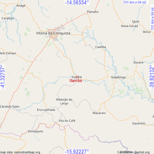
Itambé GPS coordinates[2]
15° 14' 42" South, 40° 37' 27.984" West
| Map corner | latitude | longitude |
|---|---|---|
| Upper-left | -14.56554°, | -41.32757° |
| Center: | -15.245°, | -40.62444° |
| Lower-right: | -15.92227°, | -39.92132° |
| Map W x H: | 150.9×150.9 km | = 93.8×93.8mi |
| max Lat: | 2.81972° ⇑44.4% North |
| Itambé: | -15.245° |
| min Lat: | ⇓55.6% South -33.69111° |
| min Long | Itambé | max Long |
| -72.89583° | -40.62444° | -32.41083° |
| W 72%⇐ | ⇒28% E |
Elevation
Elevation of Itambé is 357 m = 1171 ft, and this is 23.9 m = 78 ft below average elevation for this country.
| Max E: |
1603 m = 5259 ft | 49.6% |
| Avg. | 380.9 m = 1250 ft | |
| Itambé | 357 m = 1171 ft | |
Min E: |
0 m = 0 ft | 50.4% |
See also: Brazil elevation on elevation.city.
Geographical zone
Itambé is located in South Torrid zone (between Equator and Tropic of Capricorn). Distance of this Southern Tropic circle is 910.8 km =565.9 mi to South.| Distance of | km | miles | from Itambé |
|---|---|---|---|
| Equator | 1695.1 | 1053.3 | to North |
| Tropic Capricorn | 910.8 | 565.9 | to South |
| Antarctic Circle | 5706.1 | 3545.6 | to South |
| South Pole | 8312 | 5164.8 | to South |


Nearby cities:
15 places around Itambé: (largest is in red/bold)
• Almenara
104.6 km =65 mi,  184°
184°
• Anagé
89.3 km =55.5 mi,  322°
322°
• Encruzilhada
44.1 km =27.4 mi,  223°
223°
• Ibicuí
81.9 km =50.9 mi,  56°
56°
• Iguaí
79.1 km =49.2 mi,  46°
46°
• Itapetinga
40.4 km =25.1 mi,  90°
90°
• Itarantim
75.6 km =47 mi,  127°
127°
• Itororó
61.1 km =38 mi,  76°
76°
• Pau Brasil
107.2 km =66.6 mi,  103°
103°
• Pedra Azul
111.1 km =69 mi, 220°
• Poções
84.3 km =52.4 mi,  19°
19°
• São Felipe
94 km =58.4 mi,  298°
298°
• Tremedal
89.6 km =55.7 mi,  289°
289°
• Vitória da Conquista
48 km =29.8 mi,  331°
331°
• Águas Vermelhas
105.5 km =65.6 mi,  238°
238°
Sources, notices
• [Note1] Compared only with cities in Brazil existing in our database
• [Src1] Map data: © OpenStreetMap contributors (CC-BY-SA)
• [Src2] Other city data from geonames.org with taken over terms of usage.
• [Src3] Geographical zone / Annual Mean Temperature by Robert A. Rohde @ Wikipedia
