Pindamonhangaba geodata
Pindamonhangaba (São Paulo) is a populated place; located in Brazil in America/Sao_Paulo (GMT-3) time zone. With population of 132,218 people, there are 170 cities with bigger population in this country. Compared to other cities in Brazil, 78% of cities are located further ↑North; 50.9% of cities are located further →East and 68.5% of cities have lower elevation than Pindamonhangaba. Note1


Pindamonhangaba GPS coordinates[2]
22° 55' 26.004" South, 45° 27' 42.012" West
| Map corner | latitude | longitude |
|---|---|---|
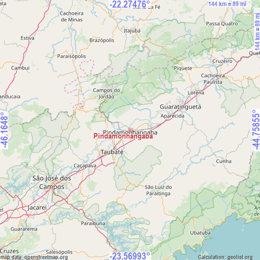
| Upper-left | -22.27476°, | -46.1648° |
| Center: | -22.92389°, | -45.46167° |
| Lower-right: | -23.56993°, | -44.75855° |
| Map W x H: | 144×144 km | = 89.5×89.5mi |
| max Lat: | 2.81972° ⇑78% North |
| Pindamonhangaba: | -22.92389° |
| min Lat: | ⇓22% South -33.69111° |
| min Long | Pindamonhangaba | max Long |
| -72.89583° | -45.46167° | -32.41083° |
| W 49.1%⇐ | ⇒50.9% E |
Elevation
Elevation of Pindamonhangaba is 562 m = 1844 ft, and this is 181.1 m = 594 ft above average elevation for this country.
| Max E: |
1603 m = 5259 ft | 31.5% |
| Pindamonhangaba | 562 m 1844 ft | |
| Avg. | 380.9 m = 1250 ft | |
Min E: |
0 m = 0 ft | 68.5% |
See also: Pindamonhangaba elevation on elevation.city.
Geographical zone
Pindamonhangaba is located in South Torrid zone (between Equator and Tropic of Capricorn). Distance of this Southern Tropic circle is 57 km =35.4 mi to South.| Distance of | km | miles | from Pindamonhangaba |
|---|---|---|---|
| Equator | 2548.9 | 1583.8 | to North |
| Tropic Capricorn | 57 | 35.4 | to South |
| Antarctic Circle | 4852.3 | 3015.1 | to South |
| South Pole | 7458.2 | 4634.3 | to South |


Nearby cities:
15 places around Pindamonhangaba: (largest is in red/bold)
• Aparecida
25.3 km =15.7 mi,  70°
70°
• Campos do Jordão
24.4 km =15.2 mi,  327°
327°
• Caçapava
31.9 km =19.8 mi,  231°
231°
• Cruzeiro
63.7 km =39.6 mi,  52°
52°
• Cunha
54 km =33.6 mi,  108°
108°
• Guaratinguetá
30.1 km =18.7 mi, 66°
• Itajubá
55.4 km =34.4 mi,  0°
0°
• Jacareí
66.8 km =41.5 mi, 230°
• Lorena
40.7 km =25.3 mi,  58°
58°
• Monte Verde
59.1 km =36.7 mi,  276°
276°
• Paraisópolis
52.5 km =32.6 mi,  321°
321°
• Piquete
45.2 km =28.1 mi,  40°
40°
• São José dos Campos
52 km =32.3 mi,  236°
236°
• Taubaté
14.9 km =9.3 mi,  220°
220°
• Tremembé
9.8 km =6.1 mi,  246°
246°
Sources, notices
• [Note1] Compared only with cities in Brazil existing in our database
• [Src1] Map data: © OpenStreetMap contributors (CC-BY-SA)
• [Src2] Other city data from geonames.org with taken over terms of usage.
• [Src3] Geographical zone / Annual Mean Temperature by Robert A. Rohde @ Wikipedia
