Paranapanema geodata
Paranapanema (São Paulo) is a populated place; located in Brazil in America/Sao_Paulo (GMT-3) time zone. With population of 16,215 people, there are 1143 cities with bigger population in this country. Compared to other cities in Brazil, 81.7% of cities are located further ↑North; 69.7% of cities are located further →East and 73.7% of cities have lower elevation than Paranapanema. Note1


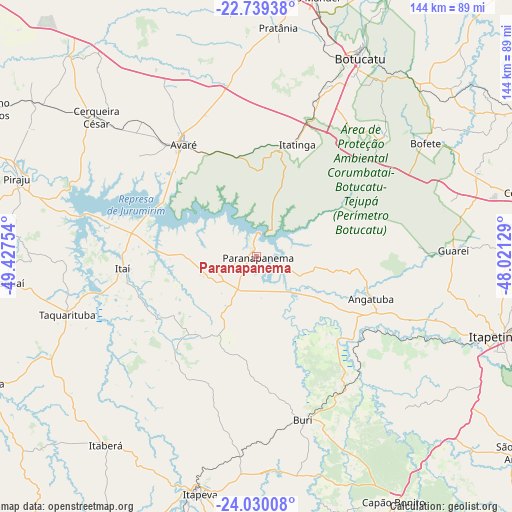
Paranapanema GPS coordinates[2]
23° 23' 10.68" South, 48° 43' 27.876" West
| Map corner | latitude | longitude |
|---|---|---|
| Upper-left | -22.73938°, | -49.42754° |
| Center: | -23.3863°, | -48.72441° |
| Lower-right: | -24.03008°, | -48.02129° |
| Map W x H: | 143.5×143.5 km | = 89.2×89.2mi |
| max Lat: | 2.81972° ⇑81.7% North |
| Paranapanema: | -23.3863° |
| min Lat: | ⇓18.3% South -33.69111° |
| min Long | Paranapanema | max Long |
| -72.89583° | -48.72441° | -32.41083° |
| W 30.3%⇐ | ⇒69.7% E |
Elevation
Elevation of Paranapanema is 610 m = 2001 ft, and this is 229.1 m = 752 ft above average elevation for this country.
| Max E: |
1603 m = 5259 ft | 26.3% |
| Paranapanema | 610 m 2001 ft | |
| Avg. | 380.9 m = 1250 ft | |
Min E: |
0 m = 0 ft | 73.7% |
See also: Brazil elevation on elevation.city.
Geographical zone
Paranapanema is located in South Torrid zone (between Equator and Tropic of Capricorn). Distance of this Southern Tropic circle is 5.6 km =3.5 mi to South.| Distance of | km | miles | from Paranapanema |
|---|---|---|---|
| Equator | 2600.3 | 1615.8 | to North |
| Tropic Capricorn | 5.6 | 3.5 | to South |
| Antarctic Circle | 4800.9 | 2983.1 | to South |
| South Pole | 7406.7 | 4602.3 | to South |


Nearby cities:
15 places around Paranapanema: (largest is in red/bold)
• Angatuba
33.8 km =21 mi,  109°
109°
• Avaré
38 km =23.6 mi,  327°
327°
• Botucatu
62.6 km =38.9 mi,  27°
27°
• Buri
47.6 km =29.6 mi,  163°
163°
• Capâo Bonito
78.8 km =49 mi,  151°
151°
• Cerqueira César
59.7 km =37.1 mi,  310°
310°
• Itaberá
67.6 km =42 mi,  218°
218°
• Itapetininga
72.2 km =44.9 mi, 108°
• Itapeva
68 km =42.3 mi,  193°
193°
• Itatinga
33.5 km =20.8 mi,  19°
19°
• Itaí
37.5 km =23.3 mi,  264°
264°
• Piraju
70.7 km =43.9 mi,  287°
287°
• Porangaba
65.5 km =40.7 mi,  69°
69°
• São Manuel
74.5 km =46.3 mi,  12°
12°
• Taquarituba
55.5 km =34.5 mi,  252°
252°
Sources, notices
• [Note1] Compared only with cities in Brazil existing in our database
• [Src1] Map data: © OpenStreetMap contributors (CC-BY-SA)
• [Src2] Other city data from geonames.org with taken over terms of usage.
• [Src3] Geographical zone / Annual Mean Temperature by Robert A. Rohde @ Wikipedia
