Jaguaquara geodata
Jaguaquara (Bahia) is a populated place; located in Brazil in America/Bahia (GMT-3) time zone. With population of 41,498 people, there are 509 cities with bigger population in this country. Compared to other cities in Brazil, 59% of cities are located further ↓South; 75.6% of cities are located further ←West and 78.8% of cities have lower elevation than Jaguaquara. Note1


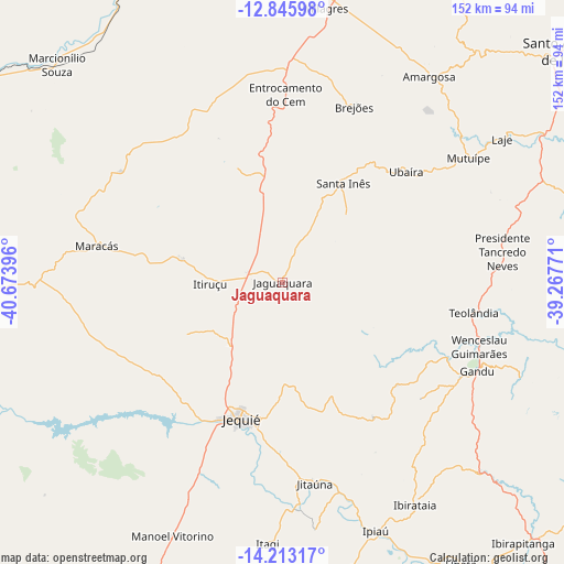
Jaguaquara GPS coordinates[2]
13° 31' 50.016" South, 39° 58' 14.988" West
| Map corner | latitude | longitude |
|---|---|---|
| Upper-left | -12.84598°, | -40.67396° |
| Center: | -13.53056°, | -39.97083° |
| Lower-right: | -14.21317°, | -39.26771° |
| Map W x H: | 152×152 km | = 94.4×94.4mi |
| max Lat: | 2.81972° ⇑41% North |
| Jaguaquara: | -13.53056° |
| min Lat: | ⇓59% South -33.69111° |
| min Long | Jaguaquara | max Long |
| -72.89583° | -39.97083° | -32.41083° |
| W 75.6%⇐ | ⇒24.4% E |
Elevation
Elevation of Jaguaquara is 675 m = 2215 ft, and this is 294.1 m = 965 ft above average elevation for this country.
| Max E: |
1603 m = 5259 ft | 21.2% |
| Jaguaquara | 675 m 2215 ft | |
| Avg. | 380.9 m = 1250 ft | |
Min E: |
0 m = 0 ft | 78.8% |
See also: Jaguaquara elevation on elevation.city.
Geographical zone
Jaguaquara is located in South Torrid zone (between Equator and Tropic of Capricorn). Distance of this Southern Tropic circle is 1101.5 km =684.4 mi to South.| Distance of | km | miles | from Jaguaquara |
|---|---|---|---|
| Equator | 1504.5 | 934.9 | to North |
| Tropic Capricorn | 1101.5 | 684.4 | to South |
| Antarctic Circle | 5896.7 | 3664 | to South |
| South Pole | 8502.6 | 5283.3 | to South |


Nearby cities:
15 places around Jaguaquara: (largest is in red/bold)
• Amargosa
68.3 km =42.4 mi,  35°
35°
• Gandu
57.4 km =35.7 mi,  114°
114°
• Iaçu
88.8 km =55.2 mi,  342°
342°
• Ibirataia
69.5 km =43.2 mi,  149°
149°
• Ipiaú
71.6 km =44.5 mi,  159°
159°
• Itagi
70.4 km =43.7 mi,  183°
183°
• Itagibá
84.9 km =52.8 mi,  170°
170°
• Itiruçu
19.4 km =12.1 mi,  269°
269°
• Jequié
38.5 km =23.9 mi,  198°
198°
• Jitaúna
54.2 km =33.7 mi, 171°
• Maracás
50.7 km =31.5 mi,  281°
281°
• Mutuípe
60.6 km =37.7 mi,  56°
56°
• Santa Inês
31.2 km =19.4 mi,  31°
31°
• Ubatã
89.4 km =55.6 mi, 147°
• Ubaíra
44.3 km =27.5 mi,  48°
48°
Sources, notices
• [Note1] Compared only with cities in Brazil existing in our database
• [Src1] Map data: © OpenStreetMap contributors (CC-BY-SA)
• [Src2] Other city data from geonames.org with taken over terms of usage.
• [Src3] Geographical zone / Annual Mean Temperature by Robert A. Rohde @ Wikipedia
