Edéia geodata
Edéia (Goiás) is a populated place; located in Brazil in America/Sao_Paulo (GMT-3) time zone. With population of 9,838 people, there are 1663 cities with bigger population in this country. Compared to other cities in Brazil, 50.3% of cities are located further ↓South; 77.7% of cities are located further →East and 70.4% of cities have lower elevation than Edéia. Note1


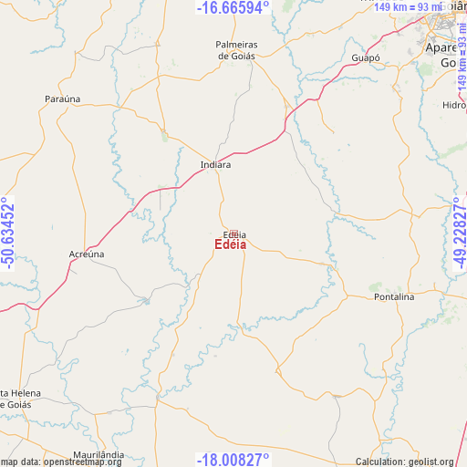
Edéia GPS coordinates[2]
17° 20' 17.988" South, 49° 55' 53.004" West
| Map corner | latitude | longitude |
|---|---|---|
| Upper-left | -16.66594°, | -50.63452° |
| Center: | -17.33833°, | -49.93139° |
| Lower-right: | -18.00827°, | -49.22827° |
| Map W x H: | 149.3×149.3 km | = 92.8×92.8mi |
| max Lat: | 2.81972° ⇑49.7% North |
| Edéia: | -17.33833° |
| min Lat: | ⇓50.3% South -33.69111° |
| min Long | Edéia | max Long |
| -72.89583° | -49.93139° | -32.41083° |
| W 22.3%⇐ | ⇒77.7% E |
Elevation
Elevation of Edéia is 579 m = 1900 ft, and this is 198.1 m = 650 ft above average elevation for this country.
| Max E: |
1603 m = 5259 ft | 29.6% |
| Edéia | 579 m 1900 ft | |
| Avg. | 380.9 m = 1250 ft | |
Min E: |
0 m = 0 ft | 70.4% |
See also: Brazil elevation on elevation.city.
Geographical zone
Edéia is located in South Torrid zone (between Equator and Tropic of Capricorn). Distance of this Southern Tropic circle is 678.1 km =421.4 mi to South.| Distance of | km | miles | from Edéia |
|---|---|---|---|
| Equator | 1927.8 | 1197.9 | to North |
| Tropic Capricorn | 678.1 | 421.4 | to South |
| Antarctic Circle | 5473.3 | 3400.9 | to South |
| South Pole | 8079.2 | 5020.2 | to South |


Nearby cities:
15 places around Edéia: (largest is in red/bold)
• Anicuns
97.6 km =60.6 mi,  358°
358°
• Aparecida de Goiânia
92.8 km =57.7 mi,  51°
51°
• Firminópolis
93 km =57.8 mi,  334°
334°
• Goiatuba
96.7 km =60.1 mi,  140°
140°
• Goiânia
102.8 km =63.9 mi,  44°
44°
• Guapó
70.6 km =43.9 mi, 36°
• Hidrolândia
85.6 km =53.2 mi,  60°
60°
• Morrinhos
98.4 km =61.1 mi,  116°
116°
• Palmeiras de Goiás
59.3 km =36.8 mi,  0°
0°
• Paraúna
70 km =43.5 mi,  308°
308°
• Piracanjuba
97.2 km =60.4 mi,  87°
87°
• Pontalina
55.4 km =34.4 mi,  112°
112°
• Santa Helena de Goiás
88.1 km =54.7 mi,  233°
233°
• São Luís de Montes Belos
101.9 km =63.3 mi, 332°
• Trindade
89.9 km =55.9 mi,  31°
31°
Sources, notices
• [Note1] Compared only with cities in Brazil existing in our database
• [Src1] Map data: © OpenStreetMap contributors (CC-BY-SA)
• [Src2] Other city data from geonames.org with taken over terms of usage.
• [Src3] Geographical zone / Annual Mean Temperature by Robert A. Rohde @ Wikipedia
