Monte Alegre de Minas geodata
Monte Alegre de Minas (Minas Gerais) is a populated place; located in Brazil in America/Sao_Paulo (GMT-3) time zone. With population of 12,451 people, there are 1428 cities with bigger population in this country. Compared to other cities in Brazil, 53% of cities are located further ↑North; 70.6% of cities are located further →East and 83% of cities have lower elevation than Monte Alegre de Minas. Note1


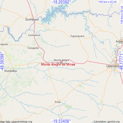
Monte Alegre de Minas GPS coordinates[2]
18° 52' 14.016" South, 48° 52' 50.988" West
| Map corner | latitude | longitude |
|---|---|---|
| Upper-left | -18.20392°, | -49.58396° |
| Center: | -18.87056°, | -48.88083° |
| Lower-right: | -19.53456°, | -48.17771° |
| Map W x H: | 148×148 km | = 92×92mi |
| max Lat: | 2.81972° ⇑53% North |
| Monte Alegre de Minas: | -18.87056° |
| min Lat: | ⇓47% South -33.69111° |
| min Long | Monte Alegre de | max Long |
| -72.89583° | -48.88083° | -32.41083° |
| W 29.4%⇐ | ⇒70.6% E |
Elevation
Elevation of Monte Alegre de Minas is 733 m = 2405 ft, and this is 352.1 m = 1155 ft above average elevation for this country.
| Max E: |
1603 m = 5259 ft | 17% |
| Monte Alegre de Minas | 733 m 2405 ft | |
| Avg. | 380.9 m = 1250 ft | |
Min E: |
0 m = 0 ft | 83% |
See also: Brazil elevation on elevation.city.
Geographical zone
Monte Alegre de Minas is located in South Torrid zone (between Equator and Tropic of Capricorn). Distance of this Southern Tropic circle is 507.7 km =315.5 mi to South.| Distance of | km | miles | from Monte Alegre de Minas |
|---|---|---|---|
| Equator | 2098.2 | 1303.8 | to North |
| Tropic Capricorn | 507.7 | 315.5 | to South |
| Antarctic Circle | 5303 | 3295.1 | to South |
| South Pole | 7908.9 | 4914.4 | to South |


Nearby cities:
15 places around Monte Alegre de Minas: (largest is in red/bold)
• Araguari
77.1 km =47.9 mi,  71°
71°
• Buriti Alegre
83 km =51.6 mi,  348°
348°
• Caldas Novas
128 km =79.5 mi,  12°
12°
• Campina Verde
97.8 km =60.8 mi,  220°
220°
• Capinópolis
75.5 km =46.9 mi,  286°
286°
• Catalão
125.9 km =78.2 mi,  51°
51°
• Centralina
46.3 km =28.8 mi,  313°
313°
• Conceição das Alagoas
127.1 km =79 mi,  156°
156°
• Frutal
128.5 km =79.8 mi,  182°
182°
• Goiatuba
107.7 km =66.9 mi,  332°
332°
• Ituiutaba
62.2 km =38.6 mi,  259°
259°
• Itumbiara
61.3 km =38.1 mi,  324°
324°
• Prata
48.8 km =30.3 mi,  185°
185°
• Tupaciguara
36.1 km =22.4 mi,  30°
30°
• Uberlândia
63.7 km =39.6 mi,  94°
94°
Sources, notices
• [Note1] Compared only with cities in Brazil existing in our database
• [Src1] Map data: © OpenStreetMap contributors (CC-BY-SA)
• [Src2] Other city data from geonames.org with taken over terms of usage.
• [Src3] Geographical zone / Annual Mean Temperature by Robert A. Rohde @ Wikipedia
