Faxinal geodata
Faxinal (Paraná) is a populated place; located in Brazil in America/Sao_Paulo (GMT-3) time zone. With population of 13,464 people, there are 1335 cities with bigger population in this country. Compared to other cities in Brazil, 86% of cities are located further ↑North; 84.5% of cities are located further →East and 91.2% of cities have lower elevation than Faxinal. Note1


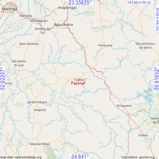
Faxinal GPS coordinates[2]
24° 0' 1.008" South, 51° 19' 9.984" West
| Map corner | latitude | longitude |
|---|---|---|
| Upper-left | -23.35635°, | -52.02257° |
| Center: | -24.00028°, | -51.31944° |
| Lower-right: | -24.641°, | -50.61632° |
| Map W x H: | 142.8×142.8 km | = 88.7×88.7mi |
| max Lat: | 2.81972° ⇑86% North |
| Faxinal: | -24.00028° |
| min Lat: | ⇓14% South -33.69111° |
| min Long | Faxinal | max Long |
| -72.89583° | -51.31944° | -32.41083° |
| W 15.5%⇐ | ⇒84.5% E |
Elevation
Elevation of Faxinal is 832 m = 2730 ft, and this is 451.1 m = 1480 ft above average elevation for this country.
| Max E: |
1603 m = 5259 ft | 8.8% |
| Faxinal | 832 m 2730 ft | |
| Avg. | 380.9 m = 1250 ft | |
Min E: |
0 m = 0 ft | 91.2% |
See also: Brazil elevation on elevation.city.
Geographical zone
Faxinal is located in South temperate zone (between Tropic of Capricorn and the Antarctic Circle). Distance of this Southern Tropic circle is 62.7 km =39 mi to North.| Distance of | km | miles | from Faxinal |
|---|---|---|---|
| Equator | 2668.6 | 1658.2 | to North |
| Tropic Capricorn | 62.7 | 39 | to North |
| Antarctic Circle | 4732.6 | 2940.7 | to South |
| South Pole | 7338.5 | 4559.9 | to South |


Nearby cities:
15 places around Faxinal: (largest is in red/bold)
• Apucarana
52 km =32.3 mi,  343°
343°
• Arapongas
65.5 km =40.7 mi,  350°
350°
• Assaí
85 km =52.8 mi,  34°
34°
• Cambé
80.7 km =50.1 mi,  2°
2°
• Cândido de Abreu
63 km =39.1 mi,  181°
181°
• Ibiporã
85.9 km =53.4 mi,  18°
18°
• Jandaia do Sul
55.1 km =34.2 mi,  323°
323°
• Londrina
78.4 km =48.7 mi,  11°
11°
• Mandaguari
61.7 km =38.3 mi, 324°
• Marialva
74.8 km =46.5 mi, 320°
• Ortigueira
44.1 km =27.4 mi,  121°
121°
• Reserva
86.5 km =53.7 mi,  146°
146°
• Rolândia
76.9 km =47.8 mi,  356°
356°
• Sarandi
83.8 km =52.1 mi, 317°
• Telêmaco Borba
80 km =49.7 mi, 116°
Sources, notices
• [Note1] Compared only with cities in Brazil existing in our database
• [Src1] Map data: © OpenStreetMap contributors (CC-BY-SA)
• [Src2] Other city data from geonames.org with taken over terms of usage.
• [Src3] Geographical zone / Annual Mean Temperature by Robert A. Rohde @ Wikipedia
