Reserva geodata
Reserva (Paraná) is a populated place; located in Brazil in America/Sao_Paulo (GMT-3) time zone. With population of 11,096 people, there are 1561 cities with bigger population in this country. Compared to other cities in Brazil, 87.2% of cities are located further ↑North; 81.8% of cities are located further →East and 97.1% of cities have lower elevation than Reserva. Note1


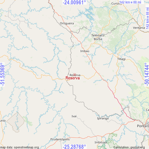
Reserva GPS coordinates[2]
24° 39' 1.008" South, 50° 51' 2.016" West
| Map corner | latitude | longitude |
|---|---|---|
| Upper-left | -24.00961°, | -51.55369° |
| Center: | -24.65028°, | -50.85056° |
| Lower-right: | -25.28768°, | -50.14744° |
| Map W x H: | 142.1×142.1 km | = 88.3×88.3mi |
| max Lat: | 2.81972° ⇑87.2% North |
| Reserva: | -24.65028° |
| min Lat: | ⇓12.8% South -33.69111° |
| min Long | Reserva | max Long |
| -72.89583° | -50.85056° | -32.41083° |
| W 18.2%⇐ | ⇒81.8% E |
Elevation
Elevation of Reserva is 943 m = 3094 ft, and this is 562.1 m = 1844 ft above average elevation for this country.
| Max E: |
1603 m = 5259 ft | 2.9% |
| Reserva | 943 m 3094 ft | |
| Avg. | 380.9 m = 1250 ft | |
Min E: |
0 m = 0 ft | 97.1% |
See also: Brazil elevation on elevation.city.
Geographical zone
Reserva is located in South temperate zone (between Tropic of Capricorn and the Antarctic Circle). Distance of this Southern Tropic circle is 134.9 km =83.8 mi to North.| Distance of | km | miles | from Reserva |
|---|---|---|---|
| Equator | 2740.9 | 1703.1 | to North |
| Tropic Capricorn | 134.9 | 83.8 | to North |
| Antarctic Circle | 4660.3 | 2895.8 | to South |
| South Pole | 7266.2 | 4515 | to South |


Nearby cities:
15 places around Reserva: (largest is in red/bold)
• Carambeí
81.4 km =50.6 mi,  114°
114°
• Castro
86.1 km =53.5 mi,  100°
100°
• Cândido de Abreu
49.7 km =30.9 mi,  280°
280°
• Faxinal
86.5 km =53.7 mi,  326°
326°
• Guarapuava
103 km =64 mi,  216°
216°
• Ibaiti
111.6 km =69.3 mi,  37°
37°
• Imbituva
69.1 km =42.9 mi,  158°
158°
• Irati
93 km =57.8 mi,  167°
167°
• Ortigueira
50.1 km =31.1 mi,  348°
348°
• Piraí do Sul
92.2 km =57.3 mi,  81°
81°
• Pitanga
92.8 km =57.7 mi,  262°
262°
• Ponta Grossa
85.3 km =53 mi,  125°
125°
• Prudentópolis
63.9 km =39.7 mi,  191°
191°
• Telêmaco Borba
43.4 km =27 mi,  33°
33°
• Tibagi
46.9 km =29.1 mi,  70°
70°
Sources, notices
• [Note1] Compared only with cities in Brazil existing in our database
• [Src1] Map data: © OpenStreetMap contributors (CC-BY-SA)
• [Src2] Other city data from geonames.org with taken over terms of usage.
• [Src3] Geographical zone / Annual Mean Temperature by Robert A. Rohde @ Wikipedia
