Cândido de Abreu geodata
Cândido de Abreu (Paraná) is a populated place; located in Brazil in America/Sao_Paulo (GMT-3) time zone. With population of 5,102 people, there are 1909 cities with bigger population in this country. Compared to other cities in Brazil, 87.2% of cities are located further ↑North; 84.6% of cities are located further →East and 66.6% of cities have lower elevation than Cândido de Abreu. Note1


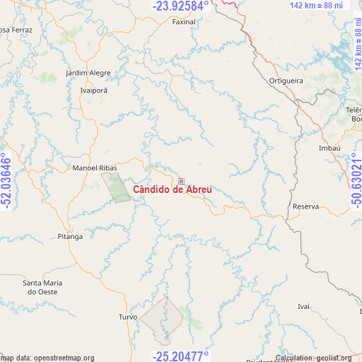
Cândido de Abreu GPS coordinates[2]
24° 34' 0.984" South, 51° 19' 59.988" West
| Map corner | latitude | longitude |
|---|---|---|
| Upper-left | -23.92584°, | -52.03646° |
| Center: | -24.56694°, | -51.33333° |
| Lower-right: | -25.20477°, | -50.63021° |
| Map W x H: | 142.2×142.2 km | = 88.4×88.4mi |
| max Lat: | 2.81972° ⇑87.2% North |
| Cândido de Abreu: | -24.56694° |
| min Lat: | ⇓12.8% South -33.69111° |
| min Long | Cândido de Abr | max Long |
| -72.89583° | -51.33333° | -32.41083° |
| W 15.4%⇐ | ⇒84.6% E |
Elevation
Elevation of Cândido de Abreu is 541 m = 1775 ft, and this is 160.1 m = 525 ft above average elevation for this country.
| Max E: |
1603 m = 5259 ft | 33.4% |
| Cândido de Abreu | 541 m 1775 ft | |
| Avg. | 380.9 m = 1250 ft | |
Min E: |
0 m = 0 ft | 66.6% |
See also: Brazil elevation on elevation.city.
Geographical zone
Cândido de Abreu is located in South temperate zone (between Tropic of Capricorn and the Antarctic Circle). Distance of this Southern Tropic circle is 125.7 km =78.1 mi to North.| Distance of | km | miles | from Cândido de Abreu |
|---|---|---|---|
| Equator | 2731.6 | 1697.3 | to North |
| Tropic Capricorn | 125.7 | 78.1 | to North |
| Antarctic Circle | 4669.6 | 2901.6 | to South |
| South Pole | 7275.5 | 4520.8 | to South |


Nearby cities:
15 places around Cândido de Abreu: (largest is in red/bold)
• Apucarana
113.7 km =70.6 mi,  353°
353°
• Campo Mourão
120.9 km =75.1 mi,  298°
298°
• Faxinal
63 km =39.1 mi,  1°
1°
• Guarapuava
92.5 km =57.5 mi,  188°
188°
• Imbituva
104.1 km =64.7 mi,  135°
135°
• Irati
121.4 km =75.4 mi,  145°
145°
• Jandaia do Sul
111.7 km =69.4 mi,  343°
343°
• Mandaguari
118.4 km =73.6 mi, 343°
• Ortigueira
55.7 km =34.6 mi,  44°
44°
• Peabiru
125.6 km =78 mi,  305°
305°
• Pitanga
48.2 km =30 mi,  243°
243°
• Prudentópolis
80.3 km =49.9 mi, 153°
• Reserva
49.7 km =30.9 mi,  100°
100°
• Telêmaco Borba
77.5 km =48.2 mi,  69°
69°
• Tibagi
93.2 km =57.9 mi,  86°
86°
Sources, notices
• [Note1] Compared only with cities in Brazil existing in our database
• [Src1] Map data: © OpenStreetMap contributors (CC-BY-SA)
• [Src2] Other city data from geonames.org with taken over terms of usage.
• [Src3] Geographical zone / Annual Mean Temperature by Robert A. Rohde @ Wikipedia
