Paraúna geodata
Paraúna (Goiás) is a populated place; located in Brazil in America/Sao_Paulo (GMT-3) time zone. With population of 9,731 people, there are 1669 cities with bigger population in this country. Compared to other cities in Brazil, 51.1% of cities are located further ↓South; 80.2% of cities are located further →East and 79.3% of cities have lower elevation than Paraúna. Note1


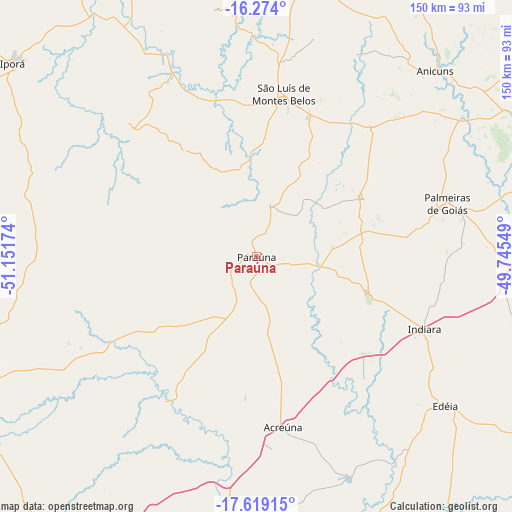
Paraúna GPS coordinates[2]
16° 56' 52.008" South, 50° 26' 54.996" West
| Map corner | latitude | longitude |
|---|---|---|
| Upper-left | -16.274°, | -51.15174° |
| Center: | -16.94778°, | -50.44861° |
| Lower-right: | -17.61915°, | -49.74549° |
| Map W x H: | 149.6×149.6 km | = 93×93mi |
| max Lat: | 2.81972° ⇑48.9% North |
| Paraúna: | -16.94778° |
| min Lat: | ⇓51.1% South -33.69111° |
| min Long | Paraúna | max Long |
| -72.89583° | -50.44861° | -32.41083° |
| W 19.8%⇐ | ⇒80.2% E |
Elevation
Elevation of Paraúna is 679 m = 2228 ft, and this is 298.1 m = 978 ft above average elevation for this country.
| Max E: |
1603 m = 5259 ft | 20.7% |
| Paraúna | 679 m 2228 ft | |
| Avg. | 380.9 m = 1250 ft | |
Min E: |
0 m = 0 ft | 79.3% |
See also: Brazil elevation on elevation.city.
Geographical zone
Paraúna is located in South Torrid zone (between Equator and Tropic of Capricorn). Distance of this Southern Tropic circle is 721.5 km =448.3 mi to South.| Distance of | km | miles | from Paraúna |
|---|---|---|---|
| Equator | 1884.4 | 1170.9 | to North |
| Tropic Capricorn | 721.5 | 448.3 | to South |
| Antarctic Circle | 5516.8 | 3428 | to South |
| South Pole | 8122.6 | 5047.1 | to South |


Nearby cities:
15 places around Paraúna: (largest is in red/bold)
• Anicuns
74.9 km =46.5 mi,  43°
43°
• Edéia
70 km =43.5 mi,  128°
128°
• Firminópolis
43.5 km =27 mi,  20°
20°
• Goianira
119.9 km =74.5 mi,  65°
65°
• Goiás
117.4 km =72.9 mi, 16°
• Guapó
98.4 km =61.1 mi,  82°
82°
• Inhumas
120.8 km =75.1 mi,  57°
57°
• Iporá
90.8 km =56.4 mi,  308°
308°
• Itaberaí
123.6 km =76.8 mi,  33°
33°
• Palmeiras de Goiás
57.8 km =35.9 mi, 74°
• Pontalina
124.2 km =77.2 mi,  121°
121°
• Rio Verde
107.4 km =66.7 mi,  208°
208°
• Santa Helena de Goiás
97.5 km =60.6 mi,  189°
189°
• São Luís de Montes Belos
47.7 km =29.6 mi,  9°
9°
• Trindade
107.4 km =66.7 mi, 72°
Sources, notices
• [Note1] Compared only with cities in Brazil existing in our database
• [Src1] Map data: © OpenStreetMap contributors (CC-BY-SA)
• [Src2] Other city data from geonames.org with taken over terms of usage.
• [Src3] Geographical zone / Annual Mean Temperature by Robert A. Rohde @ Wikipedia
