Ponta Grossa geodata
Ponta Grossa (Paraná) is a populated place; located in Brazil in America/Sao_Paulo (GMT-3) time zone. With population of 292,177 people, there are 75 cities with bigger population in this country. Compared to other cities in Brazil, 87.8% of cities are located further ↑North; 79% of cities are located further →East and 97.4% of cities have lower elevation than Ponta Grossa. Note1


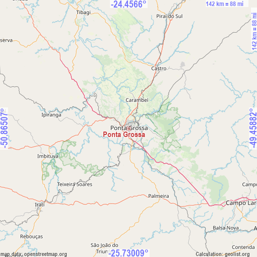
Ponta Grossa GPS coordinates[2]
25° 5' 42" South, 50° 9' 42.984" West
| Map corner | latitude | longitude |
|---|---|---|
| Upper-left | -24.4566°, | -50.86507° |
| Center: | -25.095°, | -50.16194° |
| Lower-right: | -25.73009°, | -49.45882° |
| Map W x H: | 141.6×141.6 km | = 88×88mi |
| max Lat: | 2.81972° ⇑87.8% North |
| Ponta Grossa: | -25.095° |
| min Lat: | ⇓12.2% South -33.69111° |
| min Long | Ponta Grossa | max Long |
| -72.89583° | -50.16194° | -32.41083° |
| W 21%⇐ | ⇒79% E |
Elevation
Elevation of Ponta Grossa is 954 m = 3130 ft, and this is 573.1 m = 1880 ft above average elevation for this country.
| Max E: |
1603 m = 5259 ft | 2.6% |
| Ponta Grossa | 954 m 3130 ft | |
| Avg. | 380.9 m = 1250 ft | |
Min E: |
0 m = 0 ft | 97.4% |
See also: Ponta Grossa elevation on elevation.city.
Geographical zone
Ponta Grossa is located in South temperate zone (between Tropic of Capricorn and the Antarctic Circle). Distance of this Southern Tropic circle is 184.4 km =114.6 mi to North.| Distance of | km | miles | from Ponta Grossa |
|---|---|---|---|
| Equator | 2790.3 | 1733.8 | to North |
| Tropic Capricorn | 184.4 | 114.6 | to North |
| Antarctic Circle | 4610.9 | 2865.1 | to South |
| South Pole | 7216.8 | 4484.3 | to South |


Nearby cities:
15 places around Ponta Grossa: (largest is in red/bold)
• Almirante Tamandaré
89.4 km =55.6 mi,  106°
106°
• Campo Largo
75.4 km =46.9 mi,  122°
122°
• Carambeí
16.5 km =10.3 mi,  16°
16°
• Castro
37.2 km =23.1 mi, 23°
• Imbituva
47 km =29.2 mi,  251°
251°
• Irati
64.3 km =40 mi,  229°
229°
• Itaperuçu
83.1 km =51.6 mi,  99°
99°
• Lapa
87.4 km =54.3 mi,  149°
149°
• Palmeira
40.3 km =25 mi,  157°
157°
• Piraí do Sul
66.8 km =41.5 mi, 18°
• Prudentópolis
83.2 km =51.7 mi,  260°
260°
• Reserva
85.3 km =53 mi,  305°
305°
• Rio Branco do Sul
86 km =53.4 mi, 97°
• São Mateus do Sul
89.4 km =55.6 mi,  194°
194°
• Tibagi
69.9 km =43.4 mi,  338°
338°
Sources, notices
• [Note1] Compared only with cities in Brazil existing in our database
• [Src1] Map data: © OpenStreetMap contributors (CC-BY-SA)
• [Src2] Other city data from geonames.org with taken over terms of usage.
• [Src3] Geographical zone / Annual Mean Temperature by Robert A. Rohde @ Wikipedia
