Carambeí geodata
Carambeí (Paraná) is a populated place; located in Brazil in America/Sao_Paulo (GMT-3) time zone. With population of 13,465 people, there are 1334 cities with bigger population in this country. Compared to other cities in Brazil, 87.7% of cities are located further ↑North; 78.7% of cities are located further →East and 99.1% of cities have lower elevation than Carambeí. Note1


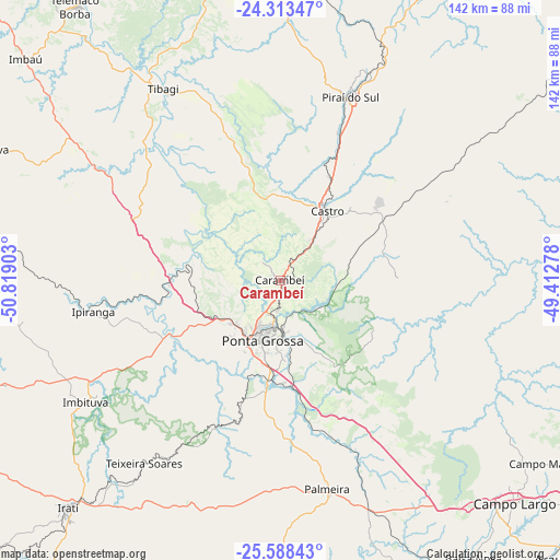
Carambeí GPS coordinates[2]
24° 57' 9.36" South, 50° 6' 57.24" West
| Map corner | latitude | longitude |
|---|---|---|
| Upper-left | -24.31347°, | -50.81903° |
| Center: | -24.9526°, | -50.1159° |
| Lower-right: | -25.58843°, | -49.41278° |
| Map W x H: | 141.8×141.8 km | = 88.1×88.1mi |
| max Lat: | 2.81972° ⇑87.7% North |
| Carambeí: | -24.9526° |
| min Lat: | ⇓12.3% South -33.69111° |
| min Long | Carambeí | max Long |
| -72.89583° | -50.1159° | -32.41083° |
| W 21.3%⇐ | ⇒78.7% E |
Elevation
Elevation of Carambeí is 1053 m = 3455 ft, and this is 672.1 m = 2205 ft above average elevation for this country.
| Max E: |
1603 m = 5259 ft | 0.90000000000001% |
| Carambeí | 1053 m 3455 ft | |
| Avg. | 380.9 m = 1250 ft | |
Min E: |
0 m = 0 ft | 99.1% |
See also: Brazil elevation on elevation.city.
Geographical zone
Carambeí is located in South temperate zone (between Tropic of Capricorn and the Antarctic Circle). Distance of this Southern Tropic circle is 168.6 km =104.8 mi to North.| Distance of | km | miles | from Carambeí |
|---|---|---|---|
| Equator | 2774.5 | 1724 | to North |
| Tropic Capricorn | 168.6 | 104.8 | to North |
| Antarctic Circle | 4626.7 | 2874.9 | to South |
| South Pole | 7232.6 | 4494.1 | to South |


Nearby cities:
15 places around Carambeí: (largest is in red/bold)
• Almirante Tamandaré
91.1 km =56.6 mi,  117°
117°
• Campo Largo
81.5 km =50.6 mi,  133°
133°
• Castro
21 km =13 mi,  29°
29°
• Imbituva
58.1 km =36.1 mi,  237°
237°
• Irati
78.6 km =48.8 mi,  223°
223°
• Itaperuçu
82.9 km =51.5 mi,  111°
111°
• Jaguariaíva
88.8 km =55.2 mi, 27°
• Palmeira
54.2 km =33.7 mi,  168°
168°
• Piraí do Sul
50.3 km =31.3 mi,  19°
19°
• Ponta Grossa
16.5 km =10.3 mi,  196°
196°
• Prudentópolis
91.5 km =56.9 mi,  251°
251°
• Reserva
81.4 km =50.6 mi,  294°
294°
• Rio Branco do Sul
84.9 km =52.8 mi, 108°
• Telêmaco Borba
86.2 km =53.6 mi,  324°
324°
• Tibagi
57.7 km =35.9 mi,  328°
328°
Sources, notices
• [Note1] Compared only with cities in Brazil existing in our database
• [Src1] Map data: © OpenStreetMap contributors (CC-BY-SA)
• [Src2] Other city data from geonames.org with taken over terms of usage.
• [Src3] Geographical zone / Annual Mean Temperature by Robert A. Rohde @ Wikipedia
