Canguçu geodata
Canguçu (Rio Grande do Sul) is a populated place; located in Brazil in America/Sao_Paulo (GMT-3) time zone. With population of 20,134 people, there are 931 cities with bigger population in this country. Compared to other cities in Brazil, 99.6% of cities are located further ↑North; 89.8% of cities are located further →East and 53.7% of cities have lower elevation than Canguçu. Note1


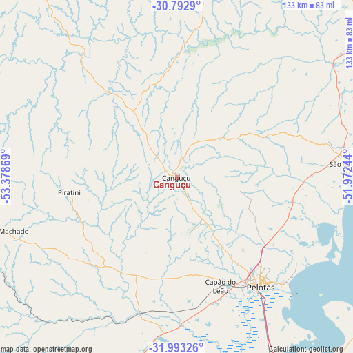
Canguçu GPS coordinates[2]
31° 23' 42" South, 52° 40' 32.016" West
| Map corner | latitude | longitude |
|---|---|---|
| Upper-left | -30.7929°, | -53.37869° |
| Center: | -31.395°, | -52.67556° |
| Lower-right: | -31.99326°, | -51.97244° |
| Map W x H: | 133.5×133.5 km | = 83×83mi |
| max Lat: | 2.81972° ⇑99.6% North |
| Canguçu: | -31.395° |
| min Lat: | ⇓0.4% South -33.69111° |
| min Long | Canguçu | max Long |
| -72.89583° | -52.67556° | -32.41083° |
| W 10.2%⇐ | ⇒89.8% E |
Elevation
Elevation of Canguçu is 406 m = 1332 ft, and this is 25.1 m = 82 ft above average elevation for this country.
| Max E: |
1603 m = 5259 ft | 46.3% |
| Canguçu | 406 m 1332 ft | |
| Avg. | 380.9 m = 1250 ft | |
Min E: |
0 m = 0 ft | 53.7% |
See also: Brazil elevation on elevation.city.
Geographical zone
Canguçu is located in South temperate zone (between Tropic of Capricorn and the Antarctic Circle). Distance of this Southern Tropic circle is 884.9 km =549.9 mi to North.| Distance of | km | miles | from Canguçu |
|---|---|---|---|
| Equator | 3490.8 | 2169.1 | to North |
| Tropic Capricorn | 884.9 | 549.9 | to North |
| Antarctic Circle | 3910.4 | 2429.8 | to South |
| South Pole | 6516.3 | 4049 | to South |


Nearby cities:
15 places around Canguçu: (largest is in red/bold)
• Arroio Grande
101.4 km =63 mi,  202°
202°
• Bagé
136.1 km =84.6 mi,  272°
272°
• Butiá
157.3 km =97.7 mi,  25°
25°
• Cachoeira do Sul
152.2 km =94.6 mi,  352°
352°
• Camaquã
102 km =63.4 mi,  53°
53°
• Caçapava do Sul
124.7 km =77.5 mi,  321°
321°
• Encruzilhada do Sul
95.8 km =59.5 mi,  8°
8°
• Herval
97.6 km =60.6 mi,  224°
224°
• Jaguarão
146 km =90.7 mi,  206°
206°
• Pelotas
52.4 km =32.6 mi,  142°
142°
• Pinheiro Machado
69.9 km =43.4 mi,  253°
253°
• Rio Grande
89.7 km =55.7 mi, 142°
• Rio Pardo
158.8 km =98.7 mi, 10°
• São Lourenço do Sul
66.3 km =41.2 mi,  87°
87°
• Tapes
146 km =90.7 mi,  56°
56°
Sources, notices
• [Note1] Compared only with cities in Brazil existing in our database
• [Src1] Map data: © OpenStreetMap contributors (CC-BY-SA)
• [Src2] Other city data from geonames.org with taken over terms of usage.
• [Src3] Geographical zone / Annual Mean Temperature by Robert A. Rohde @ Wikipedia
