Herval geodata
Herval (Rio Grande do Sul) is a populated place; located in Brazil in America/Sao_Paulo (GMT-3) time zone. With population of 18,063 people, there are 1041 cities with bigger population in this country. Compared to other cities in Brazil, 99.8% of cities are located further ↑North; 91.3% of cities are located further →East and 54.1% of cities have higher elevation than Herval. Note1


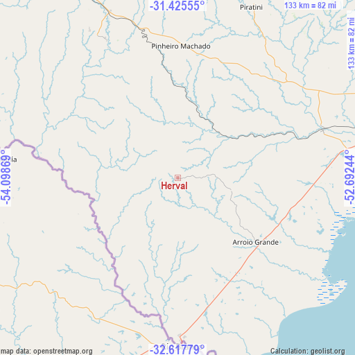
Herval GPS coordinates[2]
32° 1' 24.996" South, 53° 23' 44.016" West
| Map corner | latitude | longitude |
|---|---|---|
| Upper-left | -31.42555°, | -54.09869° |
| Center: | -32.02361°, | -53.39556° |
| Lower-right: | -32.61779°, | -52.69244° |
| Map W x H: | 132.6×132.6 km | = 82.4×82.4mi |
| max Lat: | 2.81972° ⇑99.8% North |
| Herval: | -32.02361° |
| min Lat: | ⇓0.2% South -33.69111° |
| min Long | Herval | max Long |
| -72.89583° | -53.39556° | -32.41083° |
| W 8.7%⇐ | ⇒91.3% E |
Elevation
Elevation of Herval is 283 m = 928 ft, and this is 97.9 m = 321 ft below average elevation for this country.
| Max E: |
1603 m = 5259 ft | 54.1% |
| Avg. | 380.9 m = 1250 ft | |
| Herval | 283 m = 928 ft | |
Min E: |
0 m = 0 ft | 45.9% |
See also: Brazil elevation on elevation.city.
Geographical zone
Herval is located in South temperate zone (between Tropic of Capricorn and the Antarctic Circle). Distance of this Southern Tropic circle is 954.8 km =593.3 mi to North.| Distance of | km | miles | from Herval |
|---|---|---|---|
| Equator | 3560.7 | 2212.5 | to North |
| Tropic Capricorn | 954.8 | 593.3 | to North |
| Antarctic Circle | 3840.5 | 2386.4 | to South |
| South Pole | 6446.4 | 4005.6 | to South |


Nearby cities:
15 places around Herval: (largest is in red/bold)
• Arroio Grande
37.6 km =23.4 mi,  129°
129°
• Bagé
102.2 km =63.5 mi,  318°
318°
• Camaquã
198.9 km =123.6 mi,  49°
49°
• Canguçu
97.6 km =60.6 mi,  44°
44°
• Caçapava do Sul
168 km =104.4 mi,  357°
357°
• Chuí
185.5 km =115.3 mi,  181°
181°
• Dom Pedrito
167.5 km =104.1 mi,  313°
313°
• Encruzilhada do Sul
184.3 km =114.5 mi,  26°
26°
• Jaguarão
60.3 km =37.5 mi, 178°
• Pelotas
103.5 km =64.3 mi,  74°
74°
• Pinheiro Machado
49.5 km =30.8 mi,  1°
1°
• Rio Grande
122.3 km =76 mi,  90°
90°
• Santa Vitória do Palmar
166.3 km =103.3 mi, 179°
• São Gabriel
207.2 km =128.7 mi,  334°
334°
• São Lourenço do Sul
152.8 km =94.9 mi,  61°
61°
Sources, notices
• [Note1] Compared only with cities in Brazil existing in our database
• [Src1] Map data: © OpenStreetMap contributors (CC-BY-SA)
• [Src2] Other city data from geonames.org with taken over terms of usage.
• [Src3] Geographical zone / Annual Mean Temperature by Robert A. Rohde @ Wikipedia
