Caçu geodata
Caçu (Goiás) is a populated place; located in Brazil in America/Sao_Paulo (GMT-3) time zone. With population of 10,098 people, there are 1641 cities with bigger population in this country. Compared to other cities in Brazil, 52% of cities are located further ↑North; 83.3% of cities are located further →East and 60.9% of cities have lower elevation than Caçu. Note1


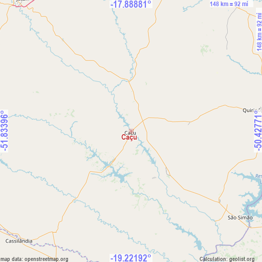
Caçu GPS coordinates[2]
18° 33' 24.012" South, 51° 7' 50.988" West
| Map corner | latitude | longitude |
|---|---|---|
| Upper-left | -17.88881°, | -51.83396° |
| Center: | -18.55667°, | -51.13083° |
| Lower-right: | -19.22192°, | -50.42771° |
| Map W x H: | 148.2×148.2 km | = 92.1×92.1mi |
| max Lat: | 2.81972° ⇑52% North |
| Caçu: | -18.55667° |
| min Lat: | ⇓48% South -33.69111° |
| min Long | Caçu | max Long |
| -72.89583° | -51.13083° | -32.41083° |
| W 16.7%⇐ | ⇒83.3% E |
Elevation
Elevation of Caçu is 482 m = 1581 ft, and this is 101.1 m = 332 ft above average elevation for this country.
| Max E: |
1603 m = 5259 ft | 39.1% |
| Caçu | 482 m 1581 ft | |
| Avg. | 380.9 m = 1250 ft | |
Min E: |
0 m = 0 ft | 60.9% |
See also: Brazil elevation on elevation.city.
Geographical zone
Caçu is located in South Torrid zone (between Equator and Tropic of Capricorn). Distance of this Southern Tropic circle is 542.6 km =337.2 mi to South.| Distance of | km | miles | from Caçu |
|---|---|---|---|
| Equator | 2063.3 | 1282.1 | to North |
| Tropic Capricorn | 542.6 | 337.2 | to South |
| Antarctic Circle | 5337.9 | 3316.8 | to South |
| South Pole | 7943.8 | 4936 | to South |


Nearby cities:
15 places around Caçu: (largest is in red/bold)
• Aparecida do Taboado
170.2 km =105.8 mi,  178°
178°
• Caiapônia
191.9 km =119.2 mi,  337°
337°
• Capinópolis
165.1 km =102.6 mi,  94°
94°
• Cassilândia
88.7 km =55.1 mi,  225°
225°
• Edéia
185.6 km =115.3 mi,  43°
43°
• Ituiutaba
181.7 km =112.9 mi,  104°
104°
• Iturama
163.1 km =101.3 mi,  142°
142°
• Jataí
97.8 km =60.8 mi,  320°
320°
• Mineiros
186 km =115.6 mi,  306°
306°
• Paranaíba
124.8 km =77.5 mi, 182°
• Quirinópolis
72.6 km =45.1 mi,  80°
80°
• Rio Verde
87 km =54.1 mi,  14°
14°
• Santa Fé do Sul
185.2 km =115.1 mi,  173°
173°
• Santa Helena de Goiás
100 km =62.1 mi,  34°
34°
• Santa Vitória
110.8 km =68.8 mi,  106°
106°
Sources, notices
• [Note1] Compared only with cities in Brazil existing in our database
• [Src1] Map data: © OpenStreetMap contributors (CC-BY-SA)
• [Src2] Other city data from geonames.org with taken over terms of usage.
• [Src3] Geographical zone / Annual Mean Temperature by Robert A. Rohde @ Wikipedia
