Cassilândia geodata
Cassilândia (Mato Grosso do Sul) is a populated place; located in Brazil in America/Campo_Grande (GMT-4) time zone. With population of 18,497 people, there are 1008 cities with bigger population in this country. Compared to other cities in Brazil, 53.6% of cities are located further ↑North; 86.6% of cities are located further →East and 60.2% of cities have lower elevation than Cassilândia. Note1


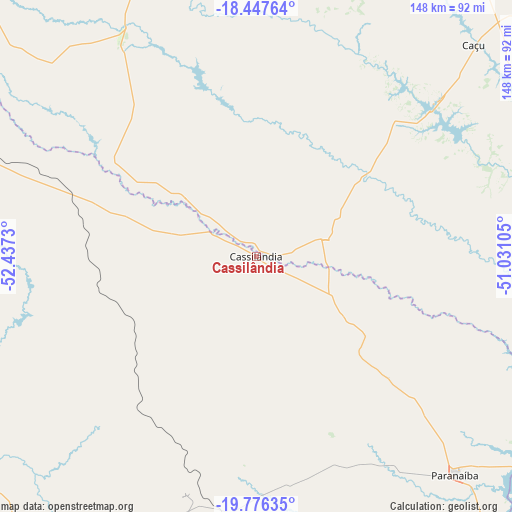
Cassilândia GPS coordinates[2]
19° 6' 47.988" South, 51° 44' 3.012" West
| Map corner | latitude | longitude |
|---|---|---|
| Upper-left | -18.44764°, | -52.4373° |
| Center: | -19.11333°, | -51.73417° |
| Lower-right: | -19.77635°, | -51.03105° |
| Map W x H: | 147.7×147.7 km | = 91.8×91.8mi |
| max Lat: | 2.81972° ⇑53.6% North |
| Cassilândia: | -19.11333° |
| min Lat: | ⇓46.4% South -33.69111° |
| min Long | Cassilândia | max Long |
| -72.89583° | -51.73417° | -32.41083° |
| W 13.4%⇐ | ⇒86.6% E |
Elevation
Elevation of Cassilândia is 475 m = 1558 ft, and this is 94.1 m = 309 ft above average elevation for this country.
| Max E: |
1603 m = 5259 ft | 39.8% |
| Cassilândia | 475 m 1558 ft | |
| Avg. | 380.9 m = 1250 ft | |
Min E: |
0 m = 0 ft | 60.2% |
See also: Brazil elevation on elevation.city.
Geographical zone
Cassilândia is located in South Torrid zone (between Equator and Tropic of Capricorn). Distance of this Southern Tropic circle is 480.7 km =298.7 mi to South.| Distance of | km | miles | from Cassilândia |
|---|---|---|---|
| Equator | 2125.2 | 1320.5 | to North |
| Tropic Capricorn | 480.7 | 298.7 | to South |
| Antarctic Circle | 5276 | 3278.4 | to South |
| South Pole | 7881.9 | 4897.6 | to South |


Nearby cities:
15 places around Cassilândia: (largest is in red/bold)
• Aparecida do Taboado
127.3 km =79.1 mi,  148°
148°
• Caçu
88.7 km =55.1 mi,  45°
45°
• Ilha Solteira
152.3 km =94.6 mi,  164°
164°
• Iturama
175.2 km =108.9 mi,  112°
112°
• Jales
178.8 km =111.1 mi,  135°
135°
• Jataí
137.2 km =85.3 mi,  0°
0°
• Paranaíba
84.7 km =52.6 mi, 137°
• Paraíso das Águas
134.7 km =83.7 mi,  274°
274°
• Pereira Barreto
181.7 km =112.9 mi, 158°
• Quirinópolis
153.9 km =95.6 mi,  61°
61°
• Rio Verde
169.2 km =105.1 mi,  30°
30°
• Santa Fé do Sul
148.5 km =92.3 mi, 145°
• Santa Helena de Goiás
187.8 km =116.7 mi,  39°
39°
• Santa Vitória
172.3 km =107.1 mi,  79°
79°
• Três Lagoas
186.2 km =115.7 mi,  179°
179°
Sources, notices
• [Note1] Compared only with cities in Brazil existing in our database
• [Src1] Map data: © OpenStreetMap contributors (CC-BY-SA)
• [Src2] Other city data from geonames.org with taken over terms of usage.
• [Src3] Geographical zone / Annual Mean Temperature by Robert A. Rohde @ Wikipedia
