Aparecida do Taboado geodata
Aparecida do Taboado (Mato Grosso do Sul) is a populated place; located in Brazil in America/Campo_Grande (GMT-4) time zone. With population of 17,332 people, there are 1073 cities with bigger population in this country. Compared to other cities in Brazil, 57.7% of cities are located further ↑North; 82.9% of cities are located further →East and 52.1% of cities have lower elevation than Aparecida do Taboado. Note1


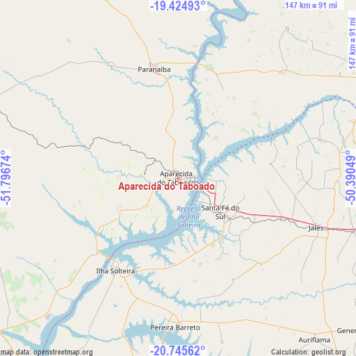
Aparecida do Taboado GPS coordinates[2]
20° 5' 12.012" South, 51° 5' 36.996" West
| Map corner | latitude | longitude |
|---|---|---|
| Upper-left | -19.42493°, | -51.79674° |
| Center: | -20.08667°, | -51.09361° |
| Lower-right: | -20.74562°, | -50.39049° |
| Map W x H: | 146.8×146.8 km | = 91.2×91.2mi |
| max Lat: | 2.81972° ⇑57.7% North |
| Aparecida do Taboado: | -20.08667° |
| min Lat: | ⇓42.3% South -33.69111° |
| min Long | Aparecida do Ta | max Long |
| -72.89583° | -51.09361° | -32.41083° |
| W 17.1%⇐ | ⇒82.9% E |
Elevation
Elevation of Aparecida do Taboado is 379 m = 1243 ft, and this is 1.9 m = 6 ft below average elevation for this country.
| Max E: |
1603 m = 5259 ft | 47.9% |
| Avg. | 380.9 m = 1250 ft | |
| Aparecida do Taboado | 379 m = 1243 ft | |
Min E: |
0 m = 0 ft | 52.1% |
See also: Brazil elevation on elevation.city.
Geographical zone
Aparecida do Taboado is located in South Torrid zone (between Equator and Tropic of Capricorn). Distance of this Southern Tropic circle is 372.5 km =231.5 mi to South.| Distance of | km | miles | from Aparecida do Taboado |
|---|---|---|---|
| Equator | 2233.4 | 1387.8 | to North |
| Tropic Capricorn | 372.5 | 231.5 | to South |
| Antarctic Circle | 5167.7 | 3211.1 | to South |
| South Pole | 7773.6 | 4830.3 | to South |


Nearby cities:
15 places around Aparecida do Taboado: (largest is in red/bold)
• Andradina
94.8 km =58.9 mi,  198°
198°
• Auriflama
87.1 km =54.1 mi,  139°
139°
• Cardoso
123.2 km =76.6 mi,  89°
89°
• Castilho
96.5 km =60 mi,  205°
205°
• Fernandópolis
91.1 km =56.6 mi,  103°
103°
• General Salgado
98.7 km =61.3 mi,  129°
129°
• Ilha Solteira
46.4 km =28.8 mi, 214°
• Iturama
102 km =63.4 mi,  66°
66°
• Jales
60.7 km =37.7 mi,  109°
109°
• Mirandopólis
116.4 km =72.3 mi,  180°
180°
• Paranaíba
46.6 km =29 mi,  347°
347°
• Pereira Barreto
61.4 km =38.2 mi, 181°
• Santa Fé do Sul
22.3 km =13.9 mi, 128°
• Três Lagoas
100.6 km =62.5 mi,  219°
219°
• Votuporanga
122.7 km =76.2 mi, 107°
Sources, notices
• [Note1] Compared only with cities in Brazil existing in our database
• [Src1] Map data: © OpenStreetMap contributors (CC-BY-SA)
• [Src2] Other city data from geonames.org with taken over terms of usage.
• [Src3] Geographical zone / Annual Mean Temperature by Robert A. Rohde @ Wikipedia
