Iturama geodata
Iturama (Minas Gerais) is a populated place; located in Brazil in America/Sao_Paulo (GMT-3) time zone. With population of 29,805 people, there are 673 cities with bigger population in this country. Compared to other cities in Brazil, 55.4% of cities are located further ↑North; 79.2% of cities are located further →East and 59.7% of cities have lower elevation than Iturama. Note1


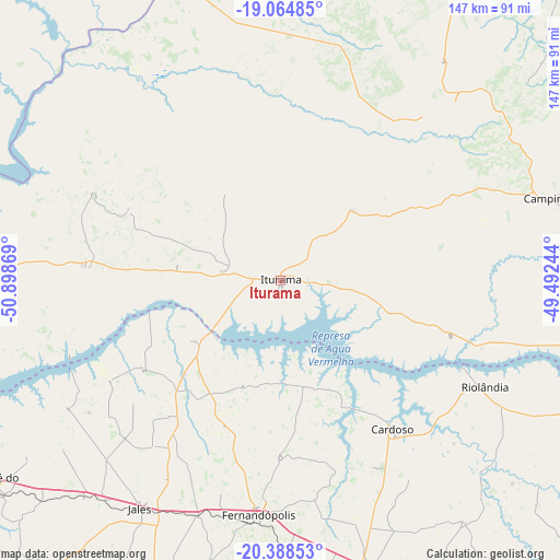
Iturama GPS coordinates[2]
19° 43' 41.016" South, 50° 11' 44.016" West
| Map corner | latitude | longitude |
|---|---|---|
| Upper-left | -19.06485°, | -50.89869° |
| Center: | -19.72806°, | -50.19556° |
| Lower-right: | -20.38853°, | -49.49244° |
| Map W x H: | 147.2×147.2 km | = 91.5×91.5mi |
| max Lat: | 2.81972° ⇑55.4% North |
| Iturama: | -19.72806° |
| min Lat: | ⇓44.6% South -33.69111° |
| min Long | Iturama | max Long |
| -72.89583° | -50.19556° | -32.41083° |
| W 20.8%⇐ | ⇒79.2% E |
Elevation
Elevation of Iturama is 469 m = 1539 ft, and this is 88.1 m = 289 ft above average elevation for this country.
| Max E: |
1603 m = 5259 ft | 40.3% |
| Iturama | 469 m 1539 ft | |
| Avg. | 380.9 m = 1250 ft | |
Min E: |
0 m = 0 ft | 59.7% |
See also: Brazil elevation on elevation.city.
Geographical zone
Iturama is located in South Torrid zone (between Equator and Tropic of Capricorn). Distance of this Southern Tropic circle is 412.4 km =256.3 mi to South.| Distance of | km | miles | from Iturama |
|---|---|---|---|
| Equator | 2193.6 | 1363 | to North |
| Tropic Capricorn | 412.4 | 256.3 | to South |
| Antarctic Circle | 5207.6 | 3235.9 | to South |
| South Pole | 7813.5 | 4855.1 | to South |


Nearby cities:
15 places around Iturama: (largest is in red/bold)
• Aparecida do Taboado
102 km =63.4 mi,  246°
246°
• Auriflama
112.9 km =70.2 mi,  199°
199°
• Campina Verde
77 km =47.8 mi,  74°
74°
• Cardoso
49.1 km =30.5 mi,  143°
143°
• Fernandópolis
62 km =38.5 mi,  184°
184°
• General Salgado
103.8 km =64.5 mi,  189°
189°
• Ituiutaba
113.8 km =70.7 mi,  42°
42°
• Jales
70.4 km =43.7 mi,  211°
211°
• Nhandeara
108.1 km =67.2 mi,  171°
171°
• Paranaíba
104.3 km =64.8 mi,  273°
273°
• Riolândia
60.6 km =37.7 mi,  117°
117°
• Santa Fé do Sul
93.3 km =58 mi,  234°
234°
• Santa Vitória
99.2 km =61.6 mi,  4°
4°
• Tanabi
115 km =71.5 mi,  150°
150°
• Votuporanga
80.7 km =50.1 mi,  163°
163°
Sources, notices
• [Note1] Compared only with cities in Brazil existing in our database
• [Src1] Map data: © OpenStreetMap contributors (CC-BY-SA)
• [Src2] Other city data from geonames.org with taken over terms of usage.
• [Src3] Geographical zone / Annual Mean Temperature by Robert A. Rohde @ Wikipedia
