Santa Fé do Sul geodata
Santa Fé do Sul (São Paulo) is a populated place; located in Brazil in America/Sao_Paulo (GMT-3) time zone. With population of 25,802 people, there are 761 cities with bigger population in this country. Compared to other cities in Brazil, 58.2% of cities are located further ↑North; 82% of cities are located further →East and 53.4% of cities have lower elevation than Santa Fé do Sul. Note1


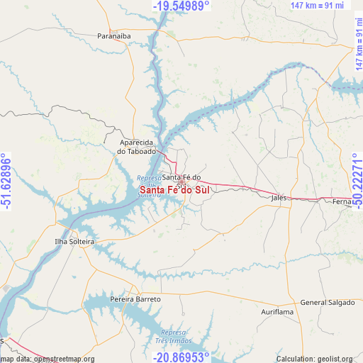
Santa Fé do Sul GPS coordinates[2]
20° 12' 39.996" South, 50° 55' 32.988" West
| Map corner | latitude | longitude |
|---|---|---|
| Upper-left | -19.54989°, | -51.62896° |
| Center: | -20.21111°, | -50.92583° |
| Lower-right: | -20.86953°, | -50.22271° |
| Map W x H: | 146.7×146.7 km | = 91.2×91.2mi |
| max Lat: | 2.81972° ⇑58.2% North |
| Santa Fé do Sul: | -20.21111° |
| min Lat: | ⇓41.8% South -33.69111° |
| min Long | Santa Fé do Su | max Long |
| -72.89583° | -50.92583° | -32.41083° |
| W 18%⇐ | ⇒82% E |
Elevation
Elevation of Santa Fé do Sul is 402 m = 1319 ft, and this is 21.1 m = 69 ft above average elevation for this country.
| Max E: |
1603 m = 5259 ft | 46.6% |
| Santa Fé do Sul | 402 m 1319 ft | |
| Avg. | 380.9 m = 1250 ft | |
Min E: |
0 m = 0 ft | 53.4% |
See also: Brazil elevation on elevation.city.
Geographical zone
Santa Fé do Sul is located in South Torrid zone (between Equator and Tropic of Capricorn). Distance of this Southern Tropic circle is 358.7 km =222.9 mi to South.| Distance of | km | miles | from Santa Fé do Sul |
|---|---|---|---|
| Equator | 2247.3 | 1396.4 | to North |
| Tropic Capricorn | 358.7 | 222.9 | to South |
| Antarctic Circle | 5153.9 | 3202.5 | to South |
| South Pole | 7759.8 | 4821.7 | to South |


Nearby cities:
15 places around Santa Fé do Sul: (largest is in red/bold)
• Andradina
89.6 km =55.7 mi,  211°
211°
• Aparecida do Taboado
22.3 km =13.9 mi,  308°
308°
• Auriflama
65.4 km =40.6 mi,  143°
143°
• Castilho
93.9 km =58.3 mi,  218°
218°
• Fernandópolis
71.3 km =44.3 mi,  96°
96°
• General Salgado
76.4 km =47.5 mi,  129°
129°
• Ilha Solteira
50 km =31.1 mi,  240°
240°
• Iturama
93.3 km =58 mi,  54°
54°
• Jales
40.2 km =25 mi, 99°
• Mirandopólis
104.2 km =64.7 mi,  190°
190°
• Nhandeara
106.5 km =66.2 mi,  119°
119°
• Paranaíba
65.5 km =40.7 mi,  334°
334°
• Pereira Barreto
51.2 km =31.8 mi,  201°
201°
• Três Lagoas
103.3 km =64.2 mi,  231°
231°
• Votuporanga
102.1 km =63.4 mi, 103°
Sources, notices
• [Note1] Compared only with cities in Brazil existing in our database
• [Src1] Map data: © OpenStreetMap contributors (CC-BY-SA)
• [Src2] Other city data from geonames.org with taken over terms of usage.
• [Src3] Geographical zone / Annual Mean Temperature by Robert A. Rohde @ Wikipedia
