Anagé geodata
Anagé (Bahia) is a populated place; located in Brazil in America/Bahia (GMT-3) time zone. With population of 3,758 people, there are 1970 cities with bigger population in this country. Compared to other cities in Brazil, 57% of cities are located further ↓South; 69.5% of cities are located further ←West and 51.9% of cities have lower elevation than Anagé. Note1


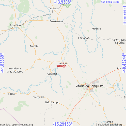
Anagé GPS coordinates[2]
14° 36' 43.992" South, 41° 8' 8.016" West
| Map corner | latitude | longitude |
|---|---|---|
| Upper-left | -13.9308°, | -41.83869° |
| Center: | -14.61222°, | -41.13556° |
| Lower-right: | -15.29153°, | -40.43244° |
| Map W x H: | 151.3×151.3 km | = 94×94mi |
| max Lat: | 2.81972° ⇑43% North |
| Anagé: | -14.61222° |
| min Lat: | ⇓57% South -33.69111° |
| min Long | Anagé | max Long |
| -72.89583° | -41.13556° | -32.41083° |
| W 69.5%⇐ | ⇒30.5% E |
Elevation
Elevation of Anagé is 378 m = 1240 ft, and this is 2.9 m = 10 ft below average elevation for this country.
| Max E: |
1603 m = 5259 ft | 48.1% |
| Avg. | 380.9 m = 1250 ft | |
| Anagé | 378 m = 1240 ft | |
Min E: |
0 m = 0 ft | 51.9% |
See also: Brazil elevation on elevation.city.
Geographical zone
Anagé is located in South Torrid zone (between Equator and Tropic of Capricorn). Distance of this Southern Tropic circle is 981.2 km =609.7 mi to South.| Distance of | km | miles | from Anagé |
|---|---|---|---|
| Equator | 1624.7 | 1009.5 | to North |
| Tropic Capricorn | 981.2 | 609.7 | to South |
| Antarctic Circle | 5776.4 | 3589.3 | to South |
| South Pole | 8382.3 | 5208.5 | to South |


Nearby cities:
15 places around Anagé: (largest is in red/bold)
• Barra da Estiva
111.6 km =69.3 mi,  349°
349°
• Brumado
72.9 km =45.3 mi,  308°
308°
• Caculé
117.6 km =73.1 mi,  275°
275°
• Encruzilhada
105 km =65.2 mi,  166°
166°
• Iguaí
113.7 km =70.6 mi,  98°
98°
• Itambé
89.3 km =55.5 mi,  142°
142°
• Itapetinga
118.8 km =73.8 mi,  126°
126°
• Ituaçu
90.5 km =56.2 mi, 348°
• Poções
83.4 km =51.8 mi,  83°
83°
• Santana
73.3 km =45.5 mi, 282°
• São Felipe
37.3 km =23.2 mi,  227°
227°
• São João do Paraíso
122.5 km =76.1 mi, 230°
• Tanhaçu
66.8 km =41.5 mi, 349°
• Tremedal
50.1 km =31.1 mi,  216°
216°
• Vitória da Conquista
42.6 km =26.5 mi, 131°
Sources, notices
• [Note1] Compared only with cities in Brazil existing in our database
• [Src1] Map data: © OpenStreetMap contributors (CC-BY-SA)
• [Src2] Other city data from geonames.org with taken over terms of usage.
• [Src3] Geographical zone / Annual Mean Temperature by Robert A. Rohde @ Wikipedia
