São Felipe geodata
São Felipe (Bahia) is a populated place; located in Brazil in America/Bahia (GMT-3) time zone. With population of 9,574 people, there are 1681 cities with bigger population in this country. Compared to other cities in Brazil, 56.4% of cities are located further ↓South; 68.8% of cities are located further ←West and 58.9% of cities have lower elevation than São Felipe. Note1


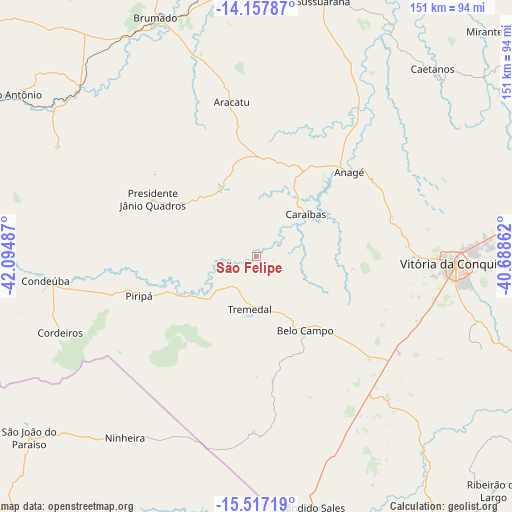
São Felipe GPS coordinates[2]
14° 50' 18.96" South, 41° 23' 30.264" West
| Map corner | latitude | longitude |
|---|---|---|
| Upper-left | -14.15787°, | -42.09487° |
| Center: | -14.8386°, | -41.39174° |
| Lower-right: | -15.51719°, | -40.68862° |
| Map W x H: | 151.1×151.1 km | = 93.9×93.9mi |
| max Lat: | 2.81972° ⇑43.6% North |
| São Felipe: | -14.8386° |
| min Lat: | ⇓56.4% South -33.69111° |
| min Long | São Felipe | max Long |
| -72.89583° | -41.39174° | -32.41083° |
| W 68.8%⇐ | ⇒31.2% E |
Elevation
Elevation of São Felipe is 463 m = 1519 ft, and this is 82.1 m = 269 ft above average elevation for this country.
| Max E: |
1603 m = 5259 ft | 41.1% |
| São Felipe | 463 m 1519 ft | |
| Avg. | 380.9 m = 1250 ft | |
Min E: |
0 m = 0 ft | 58.9% |
See also: Brazil elevation on elevation.city.
Geographical zone
São Felipe is located in South Torrid zone (between Equator and Tropic of Capricorn). Distance of this Southern Tropic circle is 956 km =594 mi to South.| Distance of | km | miles | from São Felipe |
|---|---|---|---|
| Equator | 1649.9 | 1025.2 | to North |
| Tropic Capricorn | 956 | 594 | to South |
| Antarctic Circle | 5751.3 | 3573.7 | to South |
| South Pole | 8357.2 | 5192.9 | to South |


Nearby cities:
15 places around São Felipe: (largest is in red/bold)
• Anagé
37.3 km =23.2 mi,  47°
47°
• Brumado
76.5 km =47.5 mi,  337°
337°
• Caculé
96.8 km =60.1 mi,  292°
292°
• Encruzilhada
92.8 km =57.7 mi,  146°
146°
• Itambé
94 km =58.4 mi,  118°
118°
• Itapetinga
131 km =81.4 mi,  110°
110°
• Ituaçu
114.5 km =71.1 mi,  5°
5°
• Pedra Azul
130.1 km =80.8 mi,  175°
175°
• Poções
115.6 km =71.8 mi,  72°
72°
• Santana
60.3 km =37.5 mi,  313°
313°
• São João do Paraíso
85.2 km =52.9 mi,  231°
231°
• Tanhaçu
92.2 km =57.3 mi, 9°
• Tremedal
15.4 km =9.6 mi,  187°
187°
• Vitória da Conquista
59.4 km =36.9 mi,  92°
92°
• Águas Vermelhas
101.3 km =62.9 mi, 184°
Sources, notices
• [Note1] Compared only with cities in Brazil existing in our database
• [Src1] Map data: © OpenStreetMap contributors (CC-BY-SA)
• [Src2] Other city data from geonames.org with taken over terms of usage.
• [Src3] Geographical zone / Annual Mean Temperature by Robert A. Rohde @ Wikipedia
