Canutama geodata
Canutama (Amazonas) is a populated place; located in Brazil in America/Manaus (GMT-4) time zone. With population of 6,320 people, there are 1866 cities with bigger population in this country. Compared to other cities in Brazil, 82.7% of cities are located further ↓South; 98.4% of cities are located further →East and 79.4% of cities have higher elevation than Canutama. Note1


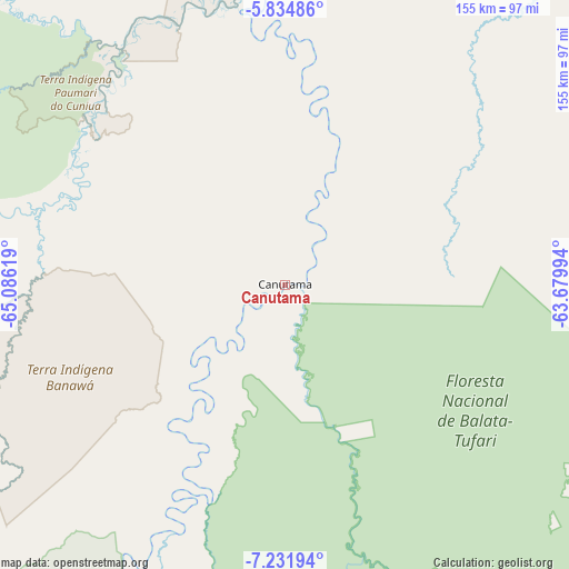
Canutama GPS coordinates[2]
6° 32' 2.004" South, 64° 22' 59.016" West
| Map corner | latitude | longitude |
|---|---|---|
| Upper-left | -5.83486°, | -65.08619° |
| Center: | -6.53389°, | -64.38306° |
| Lower-right: | -7.23194°, | -63.67994° |
| Map W x H: | 155.3×155.3 km | = 96.5×96.5mi |
| max Lat: | 2.81972° ⇑17.3% North |
| Canutama: | -6.53389° |
| min Lat: | ⇓82.7% South -33.69111° |
| min Long | Canutama | max Long |
| -72.89583° | -64.38306° | -32.41083° |
| W 1.6%⇐ | ⇒98.4% E |
Elevation
Elevation of Canutama is 49 m = 161 ft, and this is 331.9 m = 1089 ft below average elevation for this country.
| Max E: |
1603 m = 5259 ft | 79.4% |
| Avg. | 380.9 m = 1250 ft | |
| Canutama | 49 m = 161 ft | |
Min E: |
0 m = 0 ft | 20.6% |
See also: Brazil elevation on elevation.city.
Geographical zone
Canutama is located in South Torrid zone (between Equator and Tropic of Capricorn). Distance of Equator is 726.5 km =451.4 mi to North.| Distance of | km | miles | from Canutama |
|---|---|---|---|
| Equator | 726.5 | 451.4 | to North |
| Tropic Capricorn | 1879.4 | 1167.8 | to South |
| Antarctic Circle | 6674.7 | 4147.5 | to South |
| South Pole | 9280.6 | 5766.7 | to South |


Nearby cities:
14 places around Canutama: (largest is in red/bold)
• Alvarães
371.3 km =230.7 mi,  352°
352°
• Anori
431.5 km =268.1 mi,  44°
44°
• Ariquemes
403.7 km =250.8 mi,  158°
158°
• Boca do Acre
413.8 km =257.1 mi,  233°
233°
• Carauari
333.1 km =207 mi,  303°
303°
• Coari
305 km =189.5 mi,  26°
26°
• Codajás
395.3 km =245.6 mi, 40°
• Extrema
420.4 km =261.2 mi,  211°
211°
• Humaitá
184.9 km =114.9 mi,  126°
126°
• Manicoré
350.2 km =217.6 mi,  76°
76°
• Pauini
314.8 km =195.6 mi,  245°
245°
• Porto Velho
253.3 km =157.4 mi,  167°
167°
• Tefé
353.9 km =219.9 mi, 353°
• Uarini
402.2 km =249.9 mi, 348°
Sources, notices
• [Note1] Compared only with cities in Brazil existing in our database
• [Src1] Map data: © OpenStreetMap contributors (CC-BY-SA)
• [Src2] Other city data from geonames.org with taken over terms of usage.
• [Src3] Geographical zone / Annual Mean Temperature by Robert A. Rohde @ Wikipedia
