Humaitá geodata
Humaitá (Amazonas) is a populated place; located in Brazil in America/Manaus (GMT-4) time zone. With population of 31,206 people, there are 645 cities with bigger population in this country. Compared to other cities in Brazil, 77.5% of cities are located further ↓South; 98.2% of cities are located further →East and 78.7% of cities have higher elevation than Humaitá. Note1


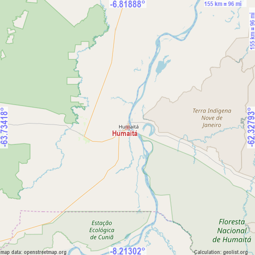
Humaitá GPS coordinates[2]
7° 30' 59.436" South, 63° 1' 51.78" West
| Map corner | latitude | longitude |
|---|---|---|
| Upper-left | -6.81888°, | -63.73418° |
| Center: | -7.51651°, | -63.03105° |
| Lower-right: | -8.21302°, | -62.32793° |
| Map W x H: | 155×155 km | = 96.3×96.3mi |
| max Lat: | 2.81972° ⇑22.5% North |
| Humaitá: | -7.51651° |
| min Lat: | ⇓77.5% South -33.69111° |
| min Long | Humaitá | max Long |
| -72.89583° | -63.03105° | -32.41083° |
| W 1.8%⇐ | ⇒98.2% E |
Elevation
Elevation of Humaitá is 54 m = 177 ft, and this is 326.9 m = 1073 ft below average elevation for this country.
| Max E: |
1603 m = 5259 ft | 78.7% |
| Avg. | 380.9 m = 1250 ft | |
| Humaitá | 54 m = 177 ft | |
Min E: |
0 m = 0 ft | 21.3% |
See also: Brazil elevation on elevation.city.
Geographical zone
Humaitá is located in South Torrid zone (between Equator and Tropic of Capricorn). Distance of Equator is 835.8 km =519.3 mi to North.| Distance of | km | miles | from Humaitá |
|---|---|---|---|
| Equator | 835.8 | 519.3 | to North |
| Tropic Capricorn | 1770.2 | 1100 | to South |
| Antarctic Circle | 6565.4 | 4079.5 | to South |
| South Pole | 9171.3 | 5698.8 | to South |


Nearby cities:
15 places around Humaitá: (largest is in red/bold)
• Anori
443.6 km =275.6 mi,  20°
20°
• Aripuanã
321.3 km =199.6 mi,  124°
124°
• Ariquemes
266.5 km =165.6 mi,  180°
180°
• Canutama
184.9 km =114.9 mi,  306°
306°
• Coari
381.7 km =237.2 mi,  358°
358°
• Codajás
423.1 km =262.9 mi,  14°
14°
• Guajará Mirim
442.6 km =275 mi,  214°
214°
• Jaru
330.8 km =205.5 mi,  169°
169°
• Ji Paraná
392.9 km =244.1 mi,  162°
162°
• Manicoré
269.4 km =167.4 mi,  45°
45°
• Novo Aripuanã
396 km =246.1 mi, 47°
• Ouro Preto do Oeste
370.3 km =230.1 mi, 166°
• Pauini
435.4 km =270.5 mi,  267°
267°
• Porto Velho
168.5 km =104.7 mi, 214°
• Presidente Médici
425.3 km =264.3 mi, 163°
Sources, notices
• [Note1] Compared only with cities in Brazil existing in our database
• [Src1] Map data: © OpenStreetMap contributors (CC-BY-SA)
• [Src2] Other city data from geonames.org with taken over terms of usage.
• [Src3] Geographical zone / Annual Mean Temperature by Robert A. Rohde @ Wikipedia
