Uarini geodata
Uarini (Amazonas) is a populated place; located in Brazil in America/Manaus (GMT-4) time zone. With population of 2,796 people, there are 1996 cities with bigger population in this country. Compared to other cities in Brazil, 95.3% of cities are located further ↓South; 98.6% of cities are located further →East and 78.2% of cities have higher elevation than Uarini. Note1


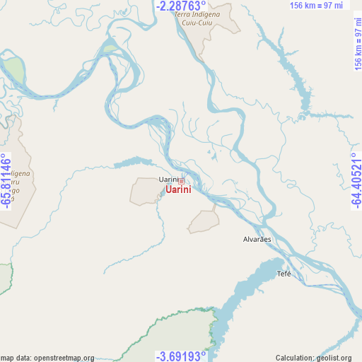
Uarini GPS coordinates[2]
2° 59' 24" South, 65° 6' 29.988" West
| Map corner | latitude | longitude |
|---|---|---|
| Upper-left | -2.28763°, | -65.81146° |
| Center: | -2.99°, | -65.10833° |
| Lower-right: | -3.69193°, | -64.40521° |
| Map W x H: | 156.1×156.1 km | = 97×97mi |
| max Lat: | 2.81972° ⇑4.7% North |
| Uarini: | -2.99° |
| min Lat: | ⇓95.3% South -33.69111° |
| min Long | Uarini | max Long |
| -72.89583° | -65.10833° | -32.41083° |
| W 1.4%⇐ | ⇒98.6% E |
Elevation
Elevation of Uarini is 56 m = 184 ft, and this is 324.9 m = 1066 ft below average elevation for this country.
| Max E: |
1603 m = 5259 ft | 78.2% |
| Avg. | 380.9 m = 1250 ft | |
| Uarini | 56 m = 184 ft | |
Min E: |
0 m = 0 ft | 21.8% |
See also: Brazil elevation on elevation.city.
Geographical zone
Uarini is located in South Torrid zone (between Equator and Tropic of Capricorn). Distance of Equator is 332.5 km =206.6 mi to North.| Distance of | km | miles | from Uarini |
|---|---|---|---|
| Equator | 332.5 | 206.6 | to North |
| Tropic Capricorn | 2273.5 | 1412.7 | to South |
| Antarctic Circle | 7068.7 | 4392.3 | to South |
| South Pole | 9674.6 | 6011.5 | to South |


Nearby cities:
15 places around Uarini: (largest is in red/bold)
• Alvarães
42.4 km =26.3 mi,  127°
127°
• Anori
394.2 km =244.9 mi,  102°
102°
• Barcelos
330.2 km =205.2 mi,  47°
47°
• Canutama
402.2 km =249.9 mi,  168°
168°
• Carauari
289.1 km =179.6 mi,  223°
223°
• Coari
249.9 km =155.3 mi,  119°
119°
• Codajás
351.5 km =218.4 mi,  105°
105°
• Fonte Boa
121.4 km =75.4 mi,  295°
295°
• Maraã
132.6 km =82.4 mi,  347°
347°
• Santa Isabel do Rio Negro
286.6 km =178.1 mi,  1°
1°
• Santo Antônio do Içá
314.6 km =195.5 mi,  267°
267°
• São Gabriel da Cachoeira
387.6 km =240.8 mi,  325°
325°
• São Paulo de Olivença
420.1 km =261 mi,  264°
264°
• Tefé
60.2 km =37.4 mi, 134°
• Tonantins
299.4 km =186 mi, 272°
Sources, notices
• [Note1] Compared only with cities in Brazil existing in our database
• [Src1] Map data: © OpenStreetMap contributors (CC-BY-SA)
• [Src2] Other city data from geonames.org with taken over terms of usage.
• [Src3] Geographical zone / Annual Mean Temperature by Robert A. Rohde @ Wikipedia
