Alvarães geodata
Alvarães (Amazonas) is a populated place; located in Brazil in America/Manaus (GMT-4) time zone. With population of 5,527 people, there are 1897 cities with bigger population in this country. Compared to other cities in Brazil, 94.6% of cities are located further ↓South; 98.5% of cities are located further →East and 76.4% of cities have higher elevation than Alvarães. Note1


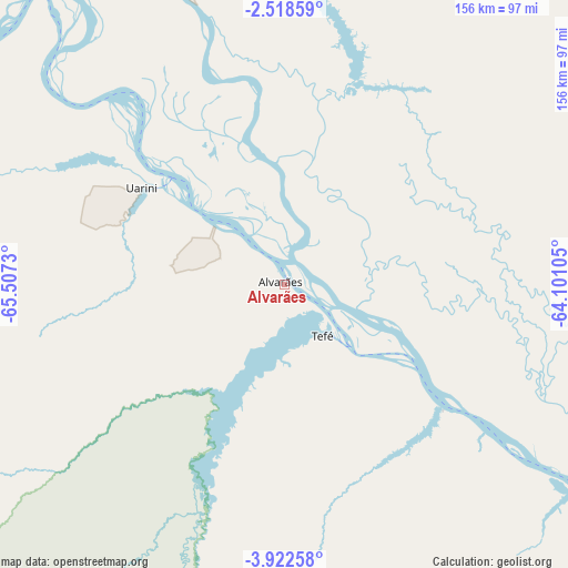
Alvarães GPS coordinates[2]
3° 13' 14.988" South, 64° 48' 15.012" West
| Map corner | latitude | longitude |
|---|---|---|
| Upper-left | -2.51859°, | -65.5073° |
| Center: | -3.22083°, | -64.80417° |
| Lower-right: | -3.92258°, | -64.10105° |
| Map W x H: | 156.1×156.1 km | = 97×97mi |
| max Lat: | 2.81972° ⇑5.4% North |
| Alvarães: | -3.22083° |
| min Lat: | ⇓94.6% South -33.69111° |
| min Long | Alvarães | max Long |
| -72.89583° | -64.80417° | -32.41083° |
| W 1.5%⇐ | ⇒98.5% E |
Elevation
Elevation of Alvarães is 69 m = 226 ft, and this is 311.9 m = 1023 ft below average elevation for this country.
| Max E: |
1603 m = 5259 ft | 76.4% |
| Avg. | 380.9 m = 1250 ft | |
| Alvarães | 69 m = 226 ft | |
Min E: |
0 m = 0 ft | 23.6% |
See also: Brazil elevation on elevation.city.
Geographical zone
Alvarães is located in South Torrid zone (between Equator and Tropic of Capricorn). Distance of Equator is 358.1 km =222.5 mi to North.| Distance of | km | miles | from Alvarães |
|---|---|---|---|
| Equator | 358.1 | 222.5 | to North |
| Tropic Capricorn | 2247.8 | 1396.7 | to South |
| Antarctic Circle | 7043.1 | 4376.4 | to South |
| South Pole | 9648.9 | 5995.5 | to South |


Nearby cities:
14 places around Alvarães: (largest is in red/bold)
• Anori
356 km =221.2 mi,  99°
99°
• Barcelos
325.5 km =202.3 mi,  39°
39°
• Canutama
371.3 km =230.7 mi,  172°
172°
• Carauari
296.6 km =184.3 mi,  231°
231°
• Coari
208 km =129.2 mi,  117°
117°
• Codajás
312.5 km =194.2 mi, 102°
• Fonte Boa
163.2 km =101.4 mi,  298°
298°
• Maraã
167.1 km =103.8 mi,  338°
338°
• Santa Isabel do Rio Negro
313 km =194.5 mi,  355°
355°
• Santo Antônio do Içá
348.4 km =216.5 mi,  272°
272°
• São Gabriel da Cachoeira
428.1 km =266 mi,  323°
323°
• Tefé
18.9 km =11.7 mi,  150°
150°
• Tonantins
335.1 km =208.2 mi,  276°
276°
• Uarini
42.4 km =26.3 mi,  307°
307°
Sources, notices
• [Note1] Compared only with cities in Brazil existing in our database
• [Src1] Map data: © OpenStreetMap contributors (CC-BY-SA)
• [Src2] Other city data from geonames.org with taken over terms of usage.
• [Src3] Geographical zone / Annual Mean Temperature by Robert A. Rohde @ Wikipedia
