Selebi-Phikwe geodata
Selebi-Phikwe (Selibe Phikwe) is a populated place; located in Botswana in Africa/Gaborone (GMT+2) time zone. With population of 53,727 people, there are 3 cities with bigger population in this country. Compared to other cities in Botswana, 71.4% of cities are located further ↓South; 96.2% of cities are located further ←West and 89.5% of cities have higher elevation than Selebi-Phikwe. Note1


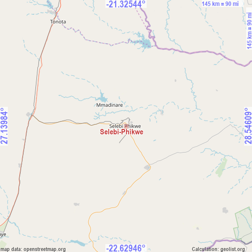
Selebi-Phikwe GPS coordinates[2]
21° 58' 44.22" South, 27° 50' 34.656" East
| Map corner | latitude | longitude |
|---|---|---|
| Upper-left | -21.32544°, | 27.13984° |
| Center: | -21.97895°, | 27.84296° |
| Lower-right: | -22.62946°, | 28.54609° |
| Map W x H: | 145×145 km | = 90.1×90.1mi |
| max Lat: | -17.80165° ⇑28.6% North |
| Selebi-Phikwe: | -21.97895° |
| min Lat: | ⇓71.4% South -26.9° |
| min Long | Selebi-Phikwe | max Long |
| 20.06667° | 27.84296° | 28.74946° |
| W 96.2%⇐ | ⇒3.8% E |
Elevation
Elevation of Selebi-Phikwe is 870 m = 2854 ft, and this is 145 m = 476 ft below average elevation for this country.
| Max E: |
1406 m = 4613 ft | 89.5% |
| Avg. | 1015 m = 3330 ft | |
| Selebi-Phikwe | 870 m = 2854 ft | |
Min E: |
676 m = 2218 ft | 10.5% |
See also: Selebi-Phikwe elevation on elevation.city.
Geographical zone
Selebi-Phikwe is located in South Torrid zone (between Equator and Tropic of Capricorn). Distance of this Southern Tropic circle is 162.1 km =100.7 mi to South.| Distance of | km | miles | from Selebi-Phikwe |
|---|---|---|---|
| Equator | 2443.8 | 1518.5 | to North |
| Tropic Capricorn | 162.1 | 100.7 | to South |
| Antarctic Circle | 4957.3 | 3080.3 | to South |
| South Pole | 7563.2 | 4699.6 | to South |


Nearby cities:
15 places around Selebi-Phikwe: (largest is in red/bold)
• Francistown
96.4 km =59.9 mi,  338°
338°
• Gobojango
92.8 km =57.7 mi,  79°
79°
• Malaka
88.3 km =54.9 mi,  216°
216°
• Mathakola
99 km =61.5 mi,  213°
213°
• Mathathane
98.8 km =61.4 mi,  109°
109°
• Maunatlala
72.1 km =44.8 mi,  197°
197°
• Mogapi
38.3 km =23.8 mi,  181°
181°
• Mogapinyana
49.8 km =30.9 mi, 210°
• Moremi
77.4 km =48.1 mi, 211°
• Palapye
97.1 km =60.3 mi,  229°
229°
• Ratholo
87.5 km =54.4 mi, 198°
• Sefophe
26.1 km =16.2 mi,  150°
150°
• Tamasane
66.7 km =41.4 mi, 222°
• Tobane
6.7 km =4.2 mi,  61°
61°
• Tonota
71.5 km =44.4 mi,  326°
326°
Sources, notices
• [Note1] Compared only with cities in Botswana existing in our database
• [Src1] Map data: © OpenStreetMap contributors (CC-BY-SA)
• [Src2] Other city data from geonames.org with taken over terms of usage.
• [Src3] Geographical zone / Annual Mean Temperature by Robert A. Rohde @ Wikipedia
