Sefophe geodata
Sefophe (Central) is a populated place; located in Botswana in Africa/Gaborone (GMT+2) time zone. With population of 4,114 people, there are 37 cities with bigger population in this country. Compared to other cities in Botswana, 70.5% of cities are located further ↓South; 98.1% of cities are located further ←West and 94.3% of cities have higher elevation than Sefophe. Note1


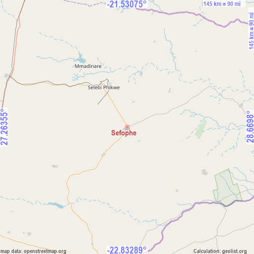
Sefophe GPS coordinates[2]
22° 10' 59.988" South, 27° 58' 0.012" East
| Map corner | latitude | longitude |
|---|---|---|
| Upper-left | -21.53075°, | 27.26355° |
| Center: | -22.18333°, | 27.96667° |
| Lower-right: | -22.83289°, | 28.6698° |
| Map W x H: | 144.8×144.8 km | = 90×90mi |
| max Lat: | -17.80165° ⇑29.5% North |
| Sefophe: | -22.18333° |
| min Lat: | ⇓70.5% South -26.9° |
| min Long | Sefophe | max Long |
| 20.06667° | 27.96667° | 28.74946° |
| W 98.1%⇐ | ⇒1.9% E |
Elevation
Elevation of Sefophe is 848 m = 2782 ft, and this is 167 m = 548 ft below average elevation for this country.
| Max E: |
1406 m = 4613 ft | 94.3% |
| Avg. | 1015 m = 3330 ft | |
| Sefophe | 848 m = 2782 ft | |
Min E: |
676 m = 2218 ft | 5.7% |
See also: Botswana elevation on elevation.city.
Geographical zone
Sefophe is located in South Torrid zone (between Equator and Tropic of Capricorn). Distance of this Southern Tropic circle is 139.4 km =86.6 mi to South.| Distance of | km | miles | from Sefophe |
|---|---|---|---|
| Equator | 2466.6 | 1532.7 | to North |
| Tropic Capricorn | 139.4 | 86.6 | to South |
| Antarctic Circle | 4934.6 | 3066.2 | to South |
| South Pole | 7540.5 | 4685.4 | to South |


Nearby cities:
15 places around Sefophe: (largest is in red/bold)
• Gobojango
87.7 km =54.5 mi,  63°
63°
• Letsheng
93.2 km =57.9 mi,  235°
235°
• Maapi
90 km =55.9 mi,  224°
224°
• Malaka
81.2 km =50.5 mi,  233°
233°
• Mathakola
90.1 km =56 mi, 228°
• Mathathane
81.1 km =50.4 mi,  96°
96°
• Maunatlala
57.6 km =35.8 mi, 216°
• Mogapi
20.6 km =12.8 mi, 221°
• Mogapinyana
42.9 km =26.7 mi, 241°
• Moremi
68.5 km =42.6 mi, 230°
• Ramokgonami
94 km =58.4 mi, 216°
• Ratholo
72.6 km =45.1 mi,  213°
213°
• Selebi-Phikwe
26.1 km =16.2 mi,  330°
330°
• Tamasane
63.8 km =39.6 mi,  245°
245°
• Tobane
26.8 km =16.7 mi,  345°
345°
Sources, notices
• [Note1] Compared only with cities in Botswana existing in our database
• [Src1] Map data: © OpenStreetMap contributors (CC-BY-SA)
• [Src2] Other city data from geonames.org with taken over terms of usage.
• [Src3] Geographical zone / Annual Mean Temperature by Robert A. Rohde @ Wikipedia
