Slave Lake geodata
Slave Lake (Alberta) is a populated place; located in Canada in America/Edmonton (GMT-6) time zone. With population of 7,661 people, there are 373 cities with bigger population in this country. Compared to other cities in Canada, 96% of cities are located further ↓South; 82.7% of cities are located further →East and 85.9% of cities have lower elevation than Slave Lake. Note1


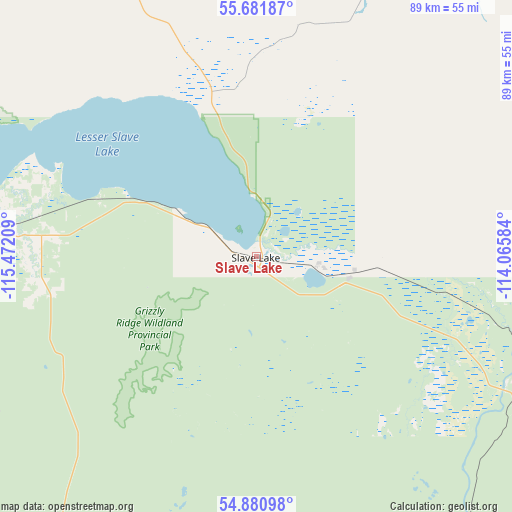
Slave Lake GPS coordinates[2]
55° 17' 0.384" North, 114° 46' 8.256" West
| Map corner | latitude | longitude |
|---|---|---|
| Upper-left | 55.68187°, | -115.47209° |
| Center: | 55.28344°, | -114.76896° |
| Lower-right: | 54.88098°, | -114.06584° |
| Map W x H: | 89.1×89 km | = 55.4×55.3mi |
| max Lat: | 73.03752° ⇑4% North |
| Slave Lake: | 55.28344° |
| min Lat: | ⇓96% South 42.05009° |
| min Long | Slave Lake | max Long |
| -139.43328° | -114.76896° | -52.70931° |
| W 17.3%⇐ | ⇒82.7% E |
Elevation
Elevation of Slave Lake is 583 m = 1913 ft, and this is 328.6 m = 1078 ft above average elevation for this country.
| Max E: |
1518 m = 4980 ft | 14.1% |
| Slave Lake | 583 m 1913 ft | |
| Avg. | 254.4 m = 835 ft | |
Min E: |
-2 m = -7 ft | 85.9% |
See also: Canada elevation on elevation.city.
Geographical zone
Slave Lake is located in North temperate zone (between Tropic of Cancer and the Arctic Circle). Distance of this North polar circle is 1254.2 km =779.3 mi to North.| Distance of | km | miles | from Slave Lake |
|---|---|---|---|
| North Pole | 3860.1 | 2398.6 | to North |
| Arctic Circle | 1254.2 | 779.3 | to North |
| Tropic Cancer | 3541 | 2200.3 | to South |
| Equator | 6146.9 | 3819.5 | to South |


Nearby cities:
15 places around Slave Lake: (largest is in red/bold)
• Athabasca
113.7 km =70.6 mi,  123°
123°
• Barrhead
130 km =80.8 mi,  169°
169°
• Bon Accord
183.2 km =113.8 mi,  151°
151°
• Falher
161.2 km =100.2 mi,  288°
288°
• Fox Creek
163.1 km =101.3 mi,  232°
232°
• Gibbons
185.8 km =115.5 mi, 150°
• High Prairie
109.8 km =68.2 mi,  278°
278°
• Lac La Biche
187.5 km =116.5 mi,  107°
107°
• Mayerthorpe
150.1 km =93.3 mi,  189°
189°
• Morinville
180 km =111.8 mi,  156°
156°
• Peace River
190.1 km =118.1 mi,  303°
303°
• Swan Hills
74.8 km =46.5 mi,  212°
212°
• Valleyview
161.6 km =100.4 mi,  261°
261°
• Westlock
138.6 km =86.1 mi, 155°
• Whitecourt
139.1 km =86.4 mi, 205°
Sources, notices
• [Note1] Compared only with cities in Canada existing in our database
• [Src1] Map data: © OpenStreetMap contributors (CC-BY-SA)
• [Src2] Other city data from geonames.org with taken over terms of usage.
• [Src3] Geographical zone / Annual Mean Temperature by Robert A. Rohde @ Wikipedia
