Beausejour geodata
Beausejour (Manitoba) is a populated place; located in Canada in America/Winnipeg (GMT-5) time zone. With population of 2,886 people, there are 628 cities with bigger population in this country. Compared to other cities in Canada, 76.3% of cities are located further ↓South; 65.7% of cities are located further →East and 63.5% of cities have lower elevation than Beausejour. Note1


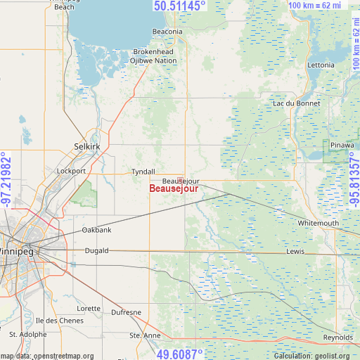
Beausejour GPS coordinates[2]
50° 3' 43.92" North, 96° 31' 0.084" West
| Map corner | latitude | longitude |
|---|---|---|
| Upper-left | 50.51145°, | -97.21982° |
| Center: | 50.0622°, | -96.51669° |
| Lower-right: | 49.6087°, | -95.81357° |
| Map W x H: | 100.4×100.4 km | = 62.4×62.4mi |
| max Lat: | 73.03752° ⇑23.7% North |
| Beausejour: | 50.0622° |
| min Lat: | ⇓76.3% South 42.05009° |
| min Long | Beausejour | max Long |
| -139.43328° | -96.51669° | -52.70931° |
| W 34.3%⇐ | ⇒65.7% E |
Elevation
Elevation of Beausejour is 248 m = 814 ft, and this is 6.4 m = 21 ft below average elevation for this country.
| Max E: |
1518 m = 4980 ft | 36.5% |
| Avg. | 254.4 m = 835 ft | |
| Beausejour | 248 m = 814 ft | |
Min E: |
-2 m = -7 ft | 63.5% |
See also: Canada elevation on elevation.city.
Geographical zone
Beausejour is located in North temperate zone (between Tropic of Cancer and the Arctic Circle). Distance of this North polar circle is 1834.8 km =1140.1 mi to North.| Distance of | km | miles | from Beausejour |
|---|---|---|---|
| North Pole | 4440.7 | 2759.3 | to North |
| Arctic Circle | 1834.8 | 1140.1 | to North |
| Tropic Cancer | 2960.5 | 1839.6 | to South |
| Equator | 5566.4 | 3458.8 | to South |


Nearby cities:
15 places around Beausejour: (largest is in red/bold)
• Garson
13.7 km =8.5 mi,  277°
277°
• Ile des Chênes
51.7 km =32.1 mi,  220°
220°
• La Broquerie
60.6 km =37.7 mi,  178°
178°
• Lac du Bonnet
38.8 km =24.1 mi,  56°
56°
• Landmark
48.6 km =30.2 mi,  206°
206°
• Lorette
44 km =27.3 mi, 215°
• Niverville
63.2 km =39.3 mi, 216°
• Pine Falls
59.9 km =37.2 mi,  20°
20°
• Powerview
60.4 km =37.5 mi, 21°
• Selkirk
27.8 km =17.3 mi,  289°
289°
• St. Adolphe
60.6 km =37.7 mi, 224°
• Steinbach
60.8 km =37.8 mi,  191°
191°
• Stonewall
58.3 km =36.2 mi, 277°
• Tyndall
10.4 km =6.5 mi, 282°
• Winnipeg
49.2 km =30.6 mi,  246°
246°
Sources, notices
• [Note1] Compared only with cities in Canada existing in our database
• [Src1] Map data: © OpenStreetMap contributors (CC-BY-SA)
• [Src2] Other city data from geonames.org with taken over terms of usage.
• [Src3] Geographical zone / Annual Mean Temperature by Robert A. Rohde @ Wikipedia
