La Broquerie geodata
La Broquerie (Manitoba) is a populated place; located in Canada in America/Winnipeg (GMT-5) time zone. With population of 1,073 people, there are 1012 cities with bigger population in this country. Compared to other cities in Canada, 70.5% of cities are located further ↓South; 65.6% of cities are located further →East and 68% of cities have lower elevation than La Broquerie. Note1


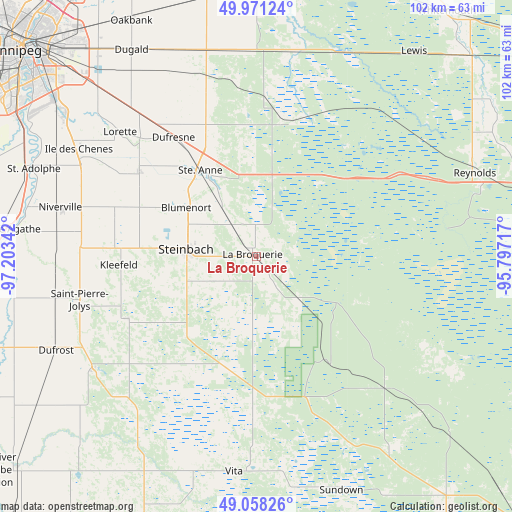
La Broquerie GPS coordinates[2]
49° 31' 0.768" North, 96° 30' 1.044" West
| Map corner | latitude | longitude |
|---|---|---|
| Upper-left | 49.97124°, | -97.20342° |
| Center: | 49.51688°, | -96.50029° |
| Lower-right: | 49.05826°, | -95.79717° |
| Map W x H: | 101.5×101.5 km | = 63.1×63.1mi |
| max Lat: | 73.03752° ⇑29.5% North |
| La Broquerie: | 49.51688° |
| min Lat: | ⇓70.5% South 42.05009° |
| min Long | La Broquerie | max Long |
| -139.43328° | -96.50029° | -52.70931° |
| W 34.4%⇐ | ⇒65.6% E |
Elevation
Elevation of La Broquerie is 280 m = 919 ft, and this is 25.6 m = 84 ft above average elevation for this country.
| Max E: |
1518 m = 4980 ft | 32% |
| La Broquerie | 280 m 919 ft | |
| Avg. | 254.4 m = 835 ft | |
Min E: |
-2 m = -7 ft | 68% |
See also: Canada elevation on elevation.city.
Geographical zone
La Broquerie is located in North temperate zone (between Tropic of Cancer and the Arctic Circle). Distance of this North polar circle is 1895.4 km =1177.7 mi to North.| Distance of | km | miles | from La Broquerie |
|---|---|---|---|
| North Pole | 4501.3 | 2797 | to North |
| Arctic Circle | 1895.4 | 1177.7 | to North |
| Tropic Cancer | 2899.8 | 1801.9 | to South |
| Equator | 5505.8 | 3421.1 | to South |


Nearby cities:
15 places around La Broquerie: (largest is in red/bold)
• Beausejour
60.6 km =37.7 mi,  358°
358°
• Garson
64.1 km =39.8 mi,  346°
346°
• Grunthal
28.7 km =17.8 mi,  244°
244°
• Headingley
76.5 km =47.5 mi,  301°
301°
• Ile des Chênes
41.3 km =25.7 mi, 301°
• Landmark
28.9 km =18 mi,  306°
306°
• Lorette
36.5 km =22.7 mi, 312°
• Morris
65.1 km =40.5 mi,  253°
253°
• Niverville
40.3 km =25 mi,  284°
284°
• Selkirk
74.9 km =46.5 mi,  338°
338°
• St. Adolphe
47.4 km =29.5 mi,  291°
291°
• St. Jean Baptiste
66.9 km =41.6 mi, 245°
• Steinbach
13.3 km =8.3 mi,  274°
274°
• Tyndall
63.9 km =39.7 mi, 349°
• Winnipeg
61.9 km =38.5 mi, 311°
Sources, notices
• [Note1] Compared only with cities in Canada existing in our database
• [Src1] Map data: © OpenStreetMap contributors (CC-BY-SA)
• [Src2] Other city data from geonames.org with taken over terms of usage.
• [Src3] Geographical zone / Annual Mean Temperature by Robert A. Rohde @ Wikipedia
