Bonavista geodata
Bonavista (Newfoundland and Labrador) is a populated place; located in Canada in America/St_Johns (GMT-2.5) time zone. With population of 3,658 people, there are 556 cities with bigger population in this country. Compared to other cities in Canada, 59.2% of cities are located further ↓South; 99.4% of cities are located further ←West and 100% of cities have higher elevation than Bonavista. Note1


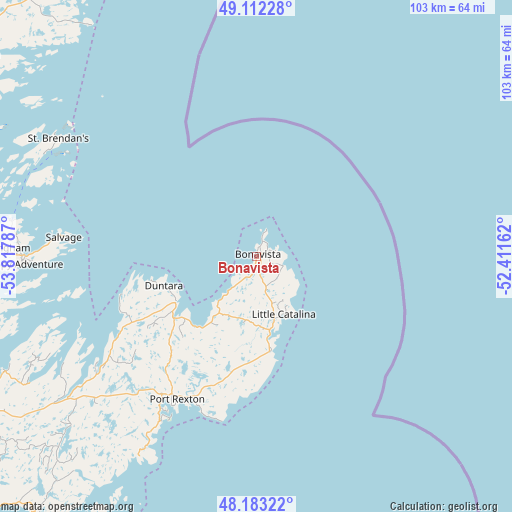
Bonavista GPS coordinates[2]
48° 38' 59.604" North, 53° 6' 53.064" West
| Map corner | latitude | longitude |
|---|---|---|
| Upper-left | 49.11228°, | -53.81787° |
| Center: | 48.64989°, | -53.11474° |
| Lower-right: | 48.18322°, | -52.41162° |
| Map W x H: | 103.3×103.3 km | = 64.2×64.2mi |
| max Lat: | 73.03752° ⇑40.8% North |
| Bonavista: | 48.64989° |
| min Lat: | ⇓59.2% South 42.05009° |
| min Long | Bonavista | max Long |
| -139.43328° | -53.11474° | -52.70931° |
| W 99.4%⇐ | ⇒0.59999999999999% E |
Elevation
Elevation of Bonavista is -2 m = -7 ft, and this is 256.4 m = 841 ft below average elevation for this country.
| Max E: |
1518 m = 4980 ft | 100% |
| Avg. | 254.4 m = 835 ft | |
| Bonavista | -2 m = -7 ft | |
Min E: |
-2 m = -7 ft | 0% |
See also: Canada elevation on elevation.city.
Geographical zone
Bonavista is located in North temperate zone (between Tropic of Cancer and the Arctic Circle). Distance of this North polar circle is 1991.8 km =1237.6 mi to North.| Distance of | km | miles | from Bonavista |
|---|---|---|---|
| North Pole | 4597.7 | 2856.9 | to North |
| Arctic Circle | 1991.8 | 1237.6 | to North |
| Tropic Cancer | 2803.4 | 1742 | to South |
| Equator | 5409.4 | 3361.2 | to South |


Nearby cities:
15 places around Bonavista: (largest is in red/bold)
• Bay Roberts
117.3 km =72.9 mi,  185°
185°
• Bloomfield
64.9 km =40.3 mi,  242°
242°
• Carbonear
102.2 km =63.5 mi,  184°
184°
• Catalina
15 km =9.3 mi,  170°
170°
• Clarenville-Shoal Harbour
81.9 km =50.9 mi,  230°
230°
• Conception Bay South
128.2 km =79.7 mi, 176°
• Gambo
82.1 km =51 mi,  280°
280°
• Gander Bay North
126.5 km =78.6 mi,  307°
307°
• Green's Harbour
116.6 km =72.5 mi, 194°
• Hare Bay
69.6 km =43.2 mi,  288°
288°
• Mount Pearl
128.4 km =79.8 mi, 168°
• St. John's
124.3 km =77.2 mi, 165°
• Torbay
113 km =70.2 mi, 165°
• Upper Island Cove
111.4 km =69.2 mi, 183°
• Wabana
113.7 km =70.6 mi, 173°
Sources, notices
• [Note1] Compared only with cities in Canada existing in our database
• [Src1] Map data: © OpenStreetMap contributors (CC-BY-SA)
• [Src2] Other city data from geonames.org with taken over terms of usage.
• [Src3] Geographical zone / Annual Mean Temperature by Robert A. Rohde @ Wikipedia
