Conception Bay South geodata
Conception Bay South (Newfoundland and Labrador) is a populated place; located in Canada in America/St_Johns (GMT-2.5) time zone. With population of 17,087 people, there are 216 cities with bigger population in this country. Compared to other cities in Canada, 50.9% of cities are located further ↓South; 99.6% of cities are located further ←West and 72.6% of cities have higher elevation than Conception Bay South. Note1


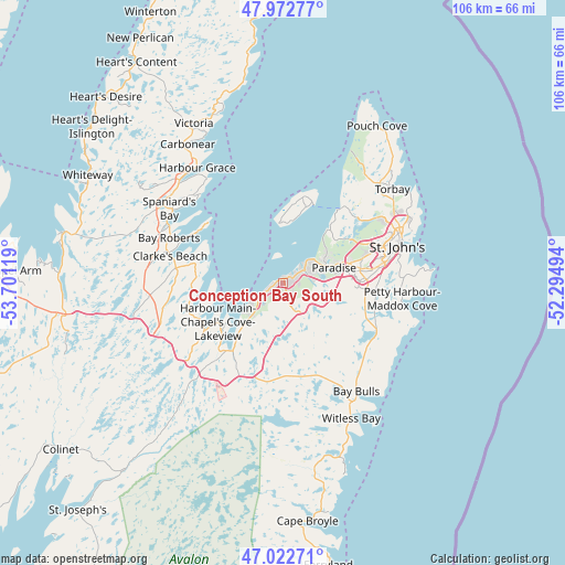
Conception Bay South GPS coordinates[2]
47° 29' 59.604" North, 52° 59' 53.016" West
| Map corner | latitude | longitude |
|---|---|---|
| Upper-left | 47.97277°, | -53.70119° |
| Center: | 47.49989°, | -52.99806° |
| Lower-right: | 47.02271°, | -52.29494° |
| Map W x H: | 105.6×105.6 km | = 65.6×65.6mi |
| max Lat: | 73.03752° ⇑49.1% North |
| Conception Bay South: | 47.49989° |
| min Lat: | ⇓50.9% South 42.05009° |
| min Long | Conception Bay | max Long |
| -139.43328° | -52.99806° | -52.70931° |
| W 99.6%⇐ | ⇒0.40000000000001% E |
Elevation
Elevation of Conception Bay South is 48 m = 157 ft, and this is 206.4 m = 677 ft below average elevation for this country.
| Max E: |
1518 m = 4980 ft | 72.6% |
| Avg. | 254.4 m = 835 ft | |
| Conception Bay South | 48 m = 157 ft | |
Min E: |
-2 m = -7 ft | 27.4% |
See also: Canada elevation on elevation.city.
Geographical zone
Conception Bay South is located in North temperate zone (between Tropic of Cancer and the Arctic Circle). Distance of this North polar circle is 2119.7 km =1317.1 mi to North.| Distance of | km | miles | from Conception Bay South |
|---|---|---|---|
| North Pole | 4725.6 | 2936.4 | to North |
| Arctic Circle | 2119.7 | 1317.1 | to North |
| Tropic Cancer | 2675.6 | 1662.5 | to South |
| Equator | 5281.5 | 3281.8 | to South |


Nearby cities:
15 places around Conception Bay South: (largest is in red/bold)
• Bay Roberts
22.9 km =14.2 mi,  299°
299°
• Blaketown
42.6 km =26.5 mi,  267°
267°
• Bloomfield
118.9 km =73.9 mi,  325°
325°
• Bonavista
128.2 km =79.7 mi,  356°
356°
• Carbonear
30.6 km =19 mi, 327°
• Catalina
113.2 km =70.3 mi, 356°
• Clarenville-Shoal Harbour
104.8 km =65.1 mi,  316°
316°
• Goulds
17.4 km =10.8 mi,  106°
106°
• Green's Harbour
40.3 km =25 mi,  291°
291°
• Marystown
166.2 km =103.3 mi,  257°
257°
• Mount Pearl
16.4 km =10.2 mi,  83°
83°
• St. John's
22.9 km =14.2 mi,  71°
71°
• Torbay
27.3 km =17 mi,  47°
47°
• Upper Island Cove
23.3 km =14.5 mi, 315°
• Wabana
15.3 km =9.5 mi,  14°
14°
Sources, notices
• [Note1] Compared only with cities in Canada existing in our database
• [Src1] Map data: © OpenStreetMap contributors (CC-BY-SA)
• [Src2] Other city data from geonames.org with taken over terms of usage.
• [Src3] Geographical zone / Annual Mean Temperature by Robert A. Rohde @ Wikipedia
