St. John's geodata
St. John's (Newfoundland and Labrador) is a seat of a first-order administrative division; located in Canada in America/St_Johns (GMT-2.5) time zone. With population of 99,182 people, there are 56 cities with bigger population in this country. Compared to other cities in Canada, 51.4% of cities are located further ↓South; 100% of cities are located further ←West and 78.3% of cities have higher elevation than St. John's. Note1


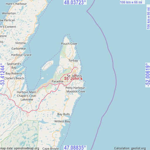
St. John's GPS coordinates[2]
47° 33' 53.784" North, 52° 42' 33.516" West
| Map corner | latitude | longitude |
|---|---|---|
| Upper-left | 48.03723°, | -53.41244° |
| Center: | 47.56494°, | -52.70931° |
| Lower-right: | 47.08835°, | -52.00619° |
| Map W x H: | 105.5×105.5 km | = 65.6×65.6mi |
| max Lat: | 73.03752° ⇑48.6% North |
| St. John's: | 47.56494° |
| min Lat: | ⇓51.4% South 42.05009° |
| min Long | St. John's | max Long |
| -139.43328° | -52.70931° | -52.70931° |
| W 100%⇐ | ⇒0% E |
Elevation
Elevation of St. John's is 35 m = 115 ft, and this is 219.4 m = 720 ft below average elevation for this country.
| Max E: |
1518 m = 4980 ft | 78.3% |
| Avg. | 254.4 m = 835 ft | |
| St. John's | 35 m = 115 ft | |
Min E: |
-2 m = -7 ft | 21.7% |
See also: St. John's elevation on elevation.city.
Geographical zone
St. John's is located in North temperate zone (between Tropic of Cancer and the Arctic Circle). Distance of this North polar circle is 2112.4 km =1312.6 mi to North.| Distance of | km | miles | from St. John's |
|---|---|---|---|
| North Pole | 4718.3 | 2931.8 | to North |
| Arctic Circle | 2112.4 | 1312.6 | to North |
| Tropic Cancer | 2682.8 | 1667 | to South |
| Equator | 5288.7 | 3286.2 | to South |


Nearby cities:
15 places around St. John's: (largest is in red/bold)
• Bay Roberts
41.8 km =26 mi,  275°
275°
• Blaketown
64.9 km =40.3 mi,  261°
261°
• Bloomfield
126.9 km =78.9 mi,  315°
315°
• Bonavista
124.3 km =77.2 mi,  345°
345°
• Carbonear
42.2 km =26.2 mi,  296°
296°
• Catalina
109.4 km =68 mi, 345°
• Clarenville-Shoal Harbour
116.3 km =72.3 mi,  306°
306°
• Conception Bay South
22.9 km =14.2 mi,  251°
251°
• Goulds
13.2 km =8.2 mi,  202°
202°
• Green's Harbour
59.6 km =37 mi, 277°
• Hare Bay
172.5 km =107.2 mi,  325°
325°
• Mount Pearl
7.6 km =4.7 mi,  225°
225°
• Torbay
11.4 km =7.1 mi, 351°
• Upper Island Cove
39.1 km =24.3 mi, 283°
• Wabana
19.4 km =12.1 mi,  292°
292°
In other languages:
- In Spanish: San Juan de Terranova
- In France: Saint-Jean de Terre-Neuve
- In German: St. John’s
- In Italian: Saint John's
- In Russian: Сент-Джонс
- In Chinese: 聖約翰斯
Sources, notices
• [Note1] Compared only with cities in Canada existing in our database
• [Src1] Map data: © OpenStreetMap contributors (CC-BY-SA)
• [Src2] Other city data from geonames.org with taken over terms of usage.
• [Src3] Geographical zone / Annual Mean Temperature by Robert A. Rohde @ Wikipedia
