Wabana geodata
Wabana (Newfoundland and Labrador) is a populated place; located in Canada in America/St_Johns (GMT-2.5) time zone. With population of 2,362 people, there are 693 cities with bigger population in this country. Compared to other cities in Canada, 51.9% of cities are located further ↓South; 99.7% of cities are located further ←West and 63.6% of cities have higher elevation than Wabana. Note1


Wabana GPS coordinates[2]
47° 37' 59.484" North, 52° 56' 53.016" West
| Map corner | latitude | longitude |
|---|---|---|
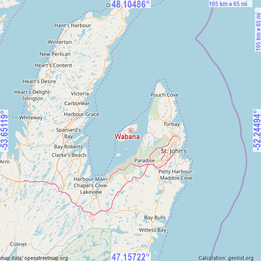
| Upper-left | 48.10486°, | -53.65119° |
| Center: | 47.63319°, | -52.94806° |
| Lower-right: | 47.15722°, | -52.24494° |
| Map W x H: | 105.4×105.4 km | = 65.5×65.5mi |
| max Lat: | 73.03752° ⇑48.1% North |
| Wabana: | 47.63319° |
| min Lat: | ⇓51.9% South 42.05009° |
| min Long | Wabana | max Long |
| -139.43328° | -52.94806° | -52.70931° |
| W 99.7%⇐ | ⇒0.3% E |
Elevation
Elevation of Wabana is 84 m = 276 ft, and this is 170.4 m = 559 ft below average elevation for this country.
| Max E: |
1518 m = 4980 ft | 63.6% |
| Avg. | 254.4 m = 835 ft | |
| Wabana | 84 m = 276 ft | |
Min E: |
-2 m = -7 ft | 36.4% |
See also: Canada elevation on elevation.city.
Geographical zone
Wabana is located in North temperate zone (between Tropic of Cancer and the Arctic Circle). Distance of this North polar circle is 2104.9 km =1307.9 mi to North.| Distance of | km | miles | from Wabana |
|---|---|---|---|
| North Pole | 4710.7 | 2927.1 | to North |
| Arctic Circle | 2104.9 | 1307.9 | to North |
| Tropic Cancer | 2690.4 | 1671.7 | to South |
| Equator | 5296.3 | 3291 | to South |


Nearby cities:
15 places around Wabana: (largest is in red/bold)
• Bay Roberts
24 km =14.9 mi,  261°
261°
• Blaketown
49.2 km =30.6 mi,  250°
250°
• Bloomfield
109.3 km =67.9 mi,  319°
319°
• Bonavista
113.7 km =70.6 mi,  353°
353°
• Carbonear
22.9 km =14.2 mi,  299°
299°
• Catalina
98.7 km =61.3 mi, 354°
• Clarenville-Shoal Harbour
97.5 km =60.6 mi,  308°
308°
• Conception Bay South
15.3 km =9.5 mi,  194°
194°
• Goulds
23.6 km =14.7 mi,  146°
146°
• Green's Harbour
41.2 km =25.6 mi,  270°
270°
• Hare Bay
156.7 km =97.4 mi,  329°
329°
• Mount Pearl
18 km =11.2 mi,  136°
136°
• St. John's
19.4 km =12.1 mi,  112°
112°
• Torbay
16.7 km =10.4 mi,  77°
77°
• Upper Island Cove
20.1 km =12.5 mi,  275°
275°
Sources, notices
• [Note1] Compared only with cities in Canada existing in our database
• [Src1] Map data: © OpenStreetMap contributors (CC-BY-SA)
• [Src2] Other city data from geonames.org with taken over terms of usage.
• [Src3] Geographical zone / Annual Mean Temperature by Robert A. Rohde @ Wikipedia
