Carbonear geodata
Carbonear (Newfoundland and Labrador) is a populated place; located in Canada in America/St_Johns (GMT-2.5) time zone. With population of 6,814 people, there are 408 cities with bigger population in this country. Compared to other cities in Canada, 52.9% of cities are located further ↓South; 99.2% of cities are located further ←West and 92.7% of cities have higher elevation than Carbonear. Note1


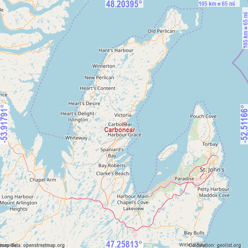
Carbonear GPS coordinates[2]
47° 43' 59.484" North, 53° 12' 53.208" West
| Map corner | latitude | longitude |
|---|---|---|
| Upper-left | 48.20395°, | -53.91791° |
| Center: | 47.73319°, | -53.21478° |
| Lower-right: | 47.25813°, | -52.51166° |
| Map W x H: | 105.2×105.2 km | = 65.4×65.4mi |
| max Lat: | 73.03752° ⇑47.1% North |
| Carbonear: | 47.73319° |
| min Lat: | ⇓52.9% South 42.05009° |
| min Long | Carbonear | max Long |
| -139.43328° | -53.21478° | -52.70931° |
| W 99.2%⇐ | ⇒0.8% E |
Elevation
Elevation of Carbonear is 11 m = 36 ft, and this is 243.4 m = 799 ft below average elevation for this country.
| Max E: |
1518 m = 4980 ft | 92.7% |
| Avg. | 254.4 m = 835 ft | |
| Carbonear | 11 m = 36 ft | |
Min E: |
-2 m = -7 ft | 7.3% |
See also: Canada elevation on elevation.city.
Geographical zone
Carbonear is located in North temperate zone (between Tropic of Cancer and the Arctic Circle). Distance of this North polar circle is 2093.7 km =1301 mi to North.| Distance of | km | miles | from Carbonear |
|---|---|---|---|
| North Pole | 4699.6 | 2920.2 | to North |
| Arctic Circle | 2093.7 | 1301 | to North |
| Tropic Cancer | 2701.5 | 1678.6 | to South |
| Equator | 5307.4 | 3297.9 | to South |


Nearby cities:
15 places around Carbonear: (largest is in red/bold)
• Bay Roberts
15.3 km =9.5 mi,  194°
194°
• Blaketown
38.2 km =23.7 mi,  223°
223°
• Bloomfield
88.3 km =54.9 mi,  324°
324°
• Bonavista
102.2 km =63.5 mi,  4°
4°
• Catalina
87.7 km =54.5 mi,  6°
6°
• Clarenville-Shoal Harbour
75.1 km =46.7 mi,  311°
311°
• Conception Bay South
30.6 km =19 mi,  147°
147°
• Goulds
45.2 km =28.1 mi,  133°
133°
• Green's Harbour
23.9 km =14.9 mi,  242°
242°
• Hare Bay
137.5 km =85.4 mi,  334°
334°
• Mount Pearl
40.4 km =25.1 mi, 126°
• St. John's
42.2 km =26.2 mi,  116°
116°
• Torbay
36.9 km =22.9 mi,  101°
101°
• Upper Island Cove
9.3 km =5.8 mi,  180°
180°
• Wabana
22.9 km =14.2 mi, 119°
Sources, notices
• [Note1] Compared only with cities in Canada existing in our database
• [Src1] Map data: © OpenStreetMap contributors (CC-BY-SA)
• [Src2] Other city data from geonames.org with taken over terms of usage.
• [Src3] Geographical zone / Annual Mean Temperature by Robert A. Rohde @ Wikipedia
