Bloomfield geodata
Bloomfield (Newfoundland and Labrador) is a populated place; located in Canada in America/St_Johns (GMT-2.5) time zone. With population of 523 people, there are 1171 cities with bigger population in this country. Compared to other cities in Canada, 56.4% of cities are located further ↓South; 98.9% of cities are located further ←West and 99.7% of cities have higher elevation than Bloomfield. Note1


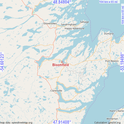
Bloomfield GPS coordinates[2]
48° 22' 59.52" North, 53° 53' 53.16" West
| Map corner | latitude | longitude |
|---|---|---|
| Upper-left | 48.84804°, | -54.60123° |
| Center: | 48.3832°, | -53.8981° |
| Lower-right: | 47.91408°, | -53.19498° |
| Map W x H: | 103.8×103.8 km | = 64.5×64.5mi |
| max Lat: | 73.03752° ⇑43.6% North |
| Bloomfield: | 48.3832° |
| min Lat: | ⇓56.4% South 42.05009° |
| min Long | Bloomfield | max Long |
| -139.43328° | -53.8981° | -52.70931° |
| W 98.9%⇐ | ⇒1.1% E |
Elevation
Elevation of Bloomfield is 1 m = 3 ft, and this is 253.4 m = 831 ft below average elevation for this country.
| Max E: |
1518 m = 4980 ft | 99.7% |
| Avg. | 254.4 m = 835 ft | |
| Bloomfield | 1 m = 3 ft | |
Min E: |
-2 m = -7 ft | 0.3% |
See also: Canada elevation on elevation.city.
Geographical zone
Bloomfield is located in North temperate zone (between Tropic of Cancer and the Arctic Circle). Distance of this North polar circle is 2021.5 km =1256.1 mi to North.| Distance of | km | miles | from Bloomfield |
|---|---|---|---|
| North Pole | 4627.4 | 2875.3 | to North |
| Arctic Circle | 2021.5 | 1256.1 | to North |
| Tropic Cancer | 2773.8 | 1723.6 | to South |
| Equator | 5379.7 | 3342.8 | to South |


Nearby cities:
15 places around Bloomfield: (largest is in red/bold)
• Bay Roberts
99 km =61.5 mi,  151°
151°
• Blaketown
103.1 km =64.1 mi,  166°
166°
• Bonavista
64.9 km =40.3 mi,  62°
62°
• Carbonear
88.3 km =54.9 mi,  144°
144°
• Catalina
62 km =38.5 mi,  76°
76°
• Clarenville-Shoal Harbour
23.2 km =14.4 mi,  193°
193°
• Conception Bay South
118.9 km =73.9 mi, 145°
• Gambo
50.2 km =31.2 mi,  332°
332°
• Gander Bay North
115.6 km =71.8 mi,  338°
338°
• Green's Harbour
88.5 km =55 mi,  160°
160°
• Hare Bay
52.6 km =32.7 mi,  350°
350°
• St. John's
126.9 km =78.9 mi, 135°
• Torbay
117.8 km =73.2 mi,  132°
132°
• Upper Island Cove
96.1 km =59.7 mi, 148°
• Wabana
109.3 km =67.9 mi, 139°
Sources, notices
• [Note1] Compared only with cities in Canada existing in our database
• [Src1] Map data: © OpenStreetMap contributors (CC-BY-SA)
• [Src2] Other city data from geonames.org with taken over terms of usage.
• [Src3] Geographical zone / Annual Mean Temperature by Robert A. Rohde @ Wikipedia
