Gambo geodata
Gambo (Newfoundland and Labrador) is a populated place; located in Canada in America/St_Johns (GMT-2.5) time zone. With population of 1,614 people, there are 836 cities with bigger population in this country. Compared to other cities in Canada, 60.2% of cities are located further ↓South; 98.6% of cities are located further ←West and 96% of cities have higher elevation than Gambo. Note1


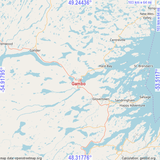
Gambo GPS coordinates[2]
48° 46' 59.52" North, 54° 12' 53.352" West
| Map corner | latitude | longitude |
|---|---|---|
| Upper-left | 49.24436°, | -54.91795° |
| Center: | 48.7832°, | -54.21482° |
| Lower-right: | 48.31776°, | -53.5117° |
| Map W x H: | 103×103 km | = 64×64mi |
| max Lat: | 73.03752° ⇑39.8% North |
| Gambo: | 48.7832° |
| min Lat: | ⇓60.2% South 42.05009° |
| min Long | Gambo | max Long |
| -139.43328° | -54.21482° | -52.70931° |
| W 98.6%⇐ | ⇒1.4% E |
Elevation
Elevation of Gambo is 7 m = 23 ft, and this is 247.4 m = 812 ft below average elevation for this country.
| Max E: |
1518 m = 4980 ft | 96% |
| Avg. | 254.4 m = 835 ft | |
| Gambo | 7 m = 23 ft | |
Min E: |
-2 m = -7 ft | 4% |
See also: Canada elevation on elevation.city.
Geographical zone
Gambo is located in North temperate zone (between Tropic of Cancer and the Arctic Circle). Distance of this North polar circle is 1977 km =1228.5 mi to North.| Distance of | km | miles | from Gambo |
|---|---|---|---|
| North Pole | 4582.9 | 2847.7 | to North |
| Arctic Circle | 1977 | 1228.5 | to North |
| Tropic Cancer | 2818.3 | 1751.2 | to South |
| Equator | 5424.2 | 3370.4 | to South |


Nearby cities:
15 places around Gambo: (largest is in red/bold)
• Bay Roberts
149.2 km =92.7 mi,  151°
151°
• Bloomfield
50.2 km =31.2 mi, 152°
• Bonavista
82.1 km =51 mi,  100°
100°
• Botwood
92.2 km =57.3 mi,  296°
296°
• Carbonear
138.2 km =85.9 mi, 147°
• Catalina
88.4 km =54.9 mi,  109°
109°
• Clarenville-Shoal Harbour
69.4 km =43.1 mi,  164°
164°
• Fogo Island
103.8 km =64.5 mi,  1°
1°
• Gander Bay North
65.9 km =40.9 mi,  342°
342°
• Grand Falls-Windsor
107.4 km =66.7 mi,  278°
278°
• Green's Harbour
138.5 km =86.1 mi, 157°
• Hare Bay
16.4 km =10.2 mi,  63°
63°
• Lewisporte
79.9 km =49.6 mi,  310°
310°
• Upper Island Cove
146.2 km =90.8 mi, 149°
• Virgin Arm-Carter's Cove
93 km =57.8 mi,  333°
333°
Sources, notices
• [Note1] Compared only with cities in Canada existing in our database
• [Src1] Map data: © OpenStreetMap contributors (CC-BY-SA)
• [Src2] Other city data from geonames.org with taken over terms of usage.
• [Src3] Geographical zone / Annual Mean Temperature by Robert A. Rohde @ Wikipedia
