Englehart geodata
Englehart (Ontario) is a populated place; located in Canada in America/Toronto (GMT-4) time zone. With population of 1,685 people, there are 815 cities with bigger population in this country. Compared to other cities in Canada, 53.4% of cities are located further ↓South; 55% of cities are located further →East and 55.3% of cities have lower elevation than Englehart. Note1


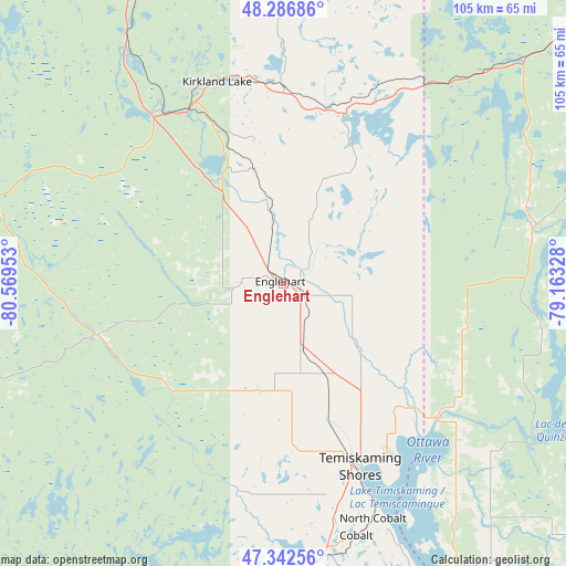
Englehart GPS coordinates[2]
47° 49' 0.696" North, 79° 51' 59.04" West
| Map corner | latitude | longitude |
|---|---|---|
| Upper-left | 48.28686°, | -80.56953° |
| Center: | 47.81686°, | -79.8664° |
| Lower-right: | 47.34256°, | -79.16328° |
| Map W x H: | 105×105 km | = 65.2×65.2mi |
| max Lat: | 73.03752° ⇑46.6% North |
| Englehart: | 47.81686° |
| min Lat: | ⇓53.4% South 42.05009° |
| min Long | Englehart | max Long |
| -139.43328° | -79.8664° | -52.70931° |
| W 45%⇐ | ⇒55% E |
Elevation
Elevation of Englehart is 201 m = 659 ft, and this is 53.4 m = 175 ft below average elevation for this country.
| Max E: |
1518 m = 4980 ft | 44.7% |
| Avg. | 254.4 m = 835 ft | |
| Englehart | 201 m = 659 ft | |
Min E: |
-2 m = -7 ft | 55.3% |
See also: Canada elevation on elevation.city.
Geographical zone
Englehart is located in North temperate zone (between Tropic of Cancer and the Arctic Circle). Distance of this North polar circle is 2084.4 km =1295.2 mi to North.| Distance of | km | miles | from Englehart |
|---|---|---|---|
| North Pole | 4690.3 | 2914.4 | to North |
| Arctic Circle | 2084.4 | 1295.2 | to North |
| Tropic Cancer | 2710.8 | 1684.4 | to South |
| Equator | 5316.7 | 3303.6 | to South |


Nearby cities:
15 places around Englehart: (largest is in red/bold)
• Capreol
146.9 km =91.3 mi,  212°
212°
• Iroquois Falls
121.7 km =75.6 mi,  330°
330°
• Kirkland Lake
38.6 km =24 mi,  340°
340°
• La Sarre
119.9 km =74.5 mi,  24°
24°
• Macamic
122 km =75.8 mi,  31°
31°
• Malartic
133.8 km =83.1 mi,  74°
74°
• Notre-Dame-du-Lac
133.7 km =83.1 mi,  152°
152°
• Rouyn-Noranda
78.2 km =48.6 mi,  53°
53°
• Saint-Bruno-de-Guigues
50.7 km =31.5 mi,  140°
140°
• Saint-Isidore
60.2 km =37.4 mi, 135°
• Temiskaming Shores
37.7 km =23.4 mi,  162°
162°
• Timmins
130.6 km =81.2 mi,  303°
303°
• Témiscaming
134.9 km =83.8 mi, 154°
• Valley East
153.8 km =95.6 mi, 213°
• Ville-Marie
62.8 km =39 mi, 148°
Sources, notices
• [Note1] Compared only with cities in Canada existing in our database
• [Src1] Map data: © OpenStreetMap contributors (CC-BY-SA)
• [Src2] Other city data from geonames.org with taken over terms of usage.
• [Src3] Geographical zone / Annual Mean Temperature by Robert A. Rohde @ Wikipedia
