Ville-Marie geodata
Ville-Marie (Quebec) is a populated place; located in Canada in America/Toronto (GMT-4) time zone. With population of 2,831 people, there are 637 cities with bigger population in this country. Compared to other cities in Canada, 50.5% of cities are located further ↑North; 52.8% of cities are located further →East and 55.6% of cities have lower elevation than Ville-Marie. Note1


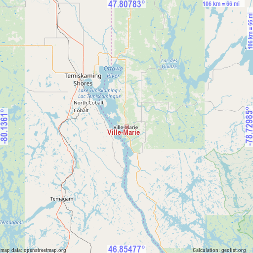
Ville-Marie GPS coordinates[2]
47° 20' 0.42" North, 79° 25' 58.692" West
| Map corner | latitude | longitude |
|---|---|---|
| Upper-left | 47.80783°, | -80.1361° |
| Center: | 47.33345°, | -79.43297° |
| Lower-right: | 46.85477°, | -78.72985° |
| Map W x H: | 106×106 km | = 65.9×65.9mi |
| max Lat: | 73.03752° ⇑50.5% North |
| Ville-Marie: | 47.33345° |
| min Lat: | ⇓49.5% South 42.05009° |
| min Long | Ville-Marie | max Long |
| -139.43328° | -79.43297° | -52.70931° |
| W 47.2%⇐ | ⇒52.8% E |
Elevation
Elevation of Ville-Marie is 204 m = 669 ft, and this is 50.4 m = 165 ft below average elevation for this country.
| Max E: |
1518 m = 4980 ft | 44.4% |
| Avg. | 254.4 m = 835 ft | |
| Ville-Marie | 204 m = 669 ft | |
Min E: |
-2 m = -7 ft | 55.6% |
See also: Canada elevation on elevation.city.
Geographical zone
Ville-Marie is located in North temperate zone (between Tropic of Cancer and the Arctic Circle). Distance of this North polar circle is 2138.2 km =1328.6 mi to North.| Distance of | km | miles | from Ville-Marie |
|---|---|---|---|
| North Pole | 4744.1 | 2947.8 | to North |
| Arctic Circle | 2138.2 | 1328.6 | to North |
| Tropic Cancer | 2657.1 | 1651 | to South |
| Equator | 5263 | 3270.3 | to South |


Nearby cities:
15 places around Ville-Marie: (largest is in red/bold)
• Cache Bay
115.3 km =71.6 mi,  201°
201°
• Capreol
132.6 km =82.4 mi,  238°
238°
• Englehart
62.8 km =39 mi,  328°
328°
• Kirkland Lake
100.9 km =62.7 mi, 333°
• Malartic
131.8 km =81.9 mi,  47°
47°
• Mattawa
126.1 km =78.4 mi,  153°
153°
• North Bay
113.1 km =70.3 mi,  181°
181°
• Notre-Dame-du-Lac
71.1 km =44.2 mi,  155°
155°
• Powassan
144.7 km =89.9 mi, 177°
• Rouyn-Noranda
105 km =65.2 mi,  16°
16°
• Saint-Bruno-de-Guigues
14.8 km =9.2 mi,  0°
0°
• Saint-Isidore
15 km =9.3 mi,  42°
42°
• Temiskaming Shores
27.7 km =17.2 mi,  310°
310°
• Témiscaming
72.7 km =45.2 mi, 159°
• Valley East
140 km =87 mi, 238°
Sources, notices
• [Note1] Compared only with cities in Canada existing in our database
• [Src1] Map data: © OpenStreetMap contributors (CC-BY-SA)
• [Src2] Other city data from geonames.org with taken over terms of usage.
• [Src3] Geographical zone / Annual Mean Temperature by Robert A. Rohde @ Wikipedia
