La Sarre geodata
La Sarre (Quebec) is a populated place; located in Canada in America/Toronto (GMT-4) time zone. With population of 7,206 people, there are 395 cities with bigger population in this country. Compared to other cities in Canada, 60.3% of cities are located further ↓South; 50.8% of cities are located further →East and 66.7% of cities have lower elevation than La Sarre. Note1


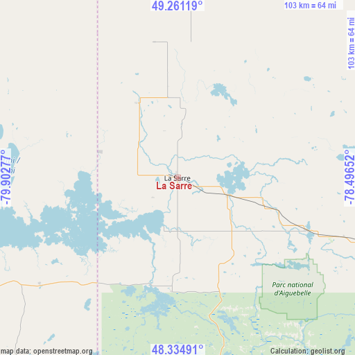
La Sarre GPS coordinates[2]
48° 48' 0.684" North, 79° 11' 58.704" West
| Map corner | latitude | longitude |
|---|---|---|
| Upper-left | 49.26119°, | -79.90277° |
| Center: | 48.80019°, | -79.19964° |
| Lower-right: | 48.33491°, | -78.49652° |
| Map W x H: | 103×103 km | = 64×64mi |
| max Lat: | 73.03752° ⇑39.7% North |
| La Sarre: | 48.80019° |
| min Lat: | ⇓60.3% South 42.05009° |
| min Long | La Sarre | max Long |
| -139.43328° | -79.19964° | -52.70931° |
| W 49.2%⇐ | ⇒50.8% E |
Elevation
Elevation of La Sarre is 269 m = 883 ft, and this is 14.6 m = 48 ft above average elevation for this country.
| Max E: |
1518 m = 4980 ft | 33.3% |
| La Sarre | 269 m 883 ft | |
| Avg. | 254.4 m = 835 ft | |
Min E: |
-2 m = -7 ft | 66.7% |
See also: Canada elevation on elevation.city.
Geographical zone
La Sarre is located in North temperate zone (between Tropic of Cancer and the Arctic Circle). Distance of this North polar circle is 1975.1 km =1227.3 mi to North.| Distance of | km | miles | from La Sarre |
|---|---|---|---|
| North Pole | 4581 | 2846.5 | to North |
| Arctic Circle | 1975.1 | 1227.3 | to North |
| Tropic Cancer | 2820.2 | 1752.4 | to South |
| Equator | 5426.1 | 3371.6 | to South |


Nearby cities:
15 places around La Sarre: (largest is in red/bold)
• Amos
83.7 km =52 mi,  108°
108°
• Barraute
122.2 km =75.9 mi, 109°
• Englehart
119.9 km =74.5 mi,  204°
204°
• Iroquois Falls
108.7 km =67.5 mi,  268°
268°
• Kirkland Lake
95.5 km =59.3 mi,  220°
220°
• Macamic
15.7 km =9.8 mi, 110°
• Malartic
108.1 km =67.2 mi,  133°
133°
• Matagami
155.2 km =96.4 mi,  47°
47°
• Rouyn-Noranda
64 km =39.8 mi,  168°
168°
• Saint-Bruno-de-Guigues
149.3 km =92.8 mi,  186°
186°
• Saint-Isidore
152.1 km =94.5 mi,  182°
182°
• Senneterre
151.1 km =93.9 mi, 107°
• Temiskaming Shores
150.2 km =93.3 mi, 194°
• Timmins
161.1 km =100.1 mi,  256°
256°
• Val-d'Or
129.6 km =80.5 mi, 127°
Sources, notices
• [Note1] Compared only with cities in Canada existing in our database
• [Src1] Map data: © OpenStreetMap contributors (CC-BY-SA)
• [Src2] Other city data from geonames.org with taken over terms of usage.
• [Src3] Geographical zone / Annual Mean Temperature by Robert A. Rohde @ Wikipedia
