Notre-Dame-du-Lac geodata
Notre-Dame-du-Lac (Quebec) is a populated place; located in Canada in America/Toronto (GMT-4) time zone. With population of 1,184 people, there are 957 cities with bigger population in this country. Compared to other cities in Canada, 52.9% of cities are located further ↑North; 50% of cities are located further ←West and 63.5% of cities have lower elevation than Notre-Dame-du-Lac. Note1


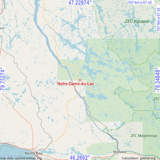
Notre-Dame-du-Lac GPS coordinates[2]
46° 45' 0.432" North, 79° 2' 58.596" West
| Map corner | latitude | longitude |
|---|---|---|
| Upper-left | 47.22974°, | -79.75274° |
| Center: | 46.75012°, | -79.04961° |
| Lower-right: | 46.2662°, | -78.34649° |
| Map W x H: | 107.1×107.1 km | = 66.5×66.5mi |
| max Lat: | 73.03752° ⇑52.9% North |
| Notre-Dame-du-Lac: | 46.75012° |
| min Lat: | ⇓47.1% South 42.05009° |
| min Long | Notre-Dame-du-L | max Long |
| -139.43328° | -79.04961° | -52.70931° |
| W 50%⇐ | ⇒50% E |
Elevation
Elevation of Notre-Dame-du-Lac is 248 m = 814 ft, and this is 6.4 m = 21 ft below average elevation for this country.
| Max E: |
1518 m = 4980 ft | 36.5% |
| Avg. | 254.4 m = 835 ft | |
| Notre-Dame-du-Lac | 248 m = 814 ft | |
Min E: |
-2 m = -7 ft | 63.5% |
See also: Canada elevation on elevation.city.
Geographical zone
Notre-Dame-du-Lac is located in North temperate zone (between Tropic of Cancer and the Arctic Circle). Distance of this North polar circle is 2203 km =1368.9 mi to North.| Distance of | km | miles | from Notre-Dame-du-Lac |
|---|---|---|---|
| North Pole | 4808.9 | 2988.1 | to North |
| Arctic Circle | 2203 | 1368.9 | to North |
| Tropic Cancer | 2592.2 | 1610.7 | to South |
| Equator | 5198.1 | 3229.9 | to South |


Nearby cities:
15 places around Notre-Dame-du-Lac: (largest is in red/bold)
• Cache Bay
83.1 km =51.6 mi,  239°
239°
• Capreol
142.7 km =88.7 mi,  268°
268°
• Deep River
139.1 km =86.4 mi,  121°
121°
• Englehart
133.7 km =83.1 mi,  332°
332°
• Greater Sudbury
151 km =93.8 mi,  258°
258°
• Mattawa
55.1 km =34.2 mi,  150°
150°
• North Bay
57.8 km =35.9 mi,  213°
213°
• Powassan
82.9 km =51.5 mi,  196°
196°
• Saint-Bruno-de-Guigues
84.8 km =52.7 mi,  339°
339°
• Saint-Isidore
78.3 km =48.7 mi,  346°
346°
• South River
105.1 km =65.3 mi,  194°
194°
• Temiskaming Shores
96.8 km =60.1 mi, 328°
• Témiscaming
4.8 km =3 mi,  228°
228°
• Valley East
149 km =92.6 mi, 266°
• Ville-Marie
71.1 km =44.2 mi, 335°
Sources, notices
• [Note1] Compared only with cities in Canada existing in our database
• [Src1] Map data: © OpenStreetMap contributors (CC-BY-SA)
• [Src2] Other city data from geonames.org with taken over terms of usage.
• [Src3] Geographical zone / Annual Mean Temperature by Robert A. Rohde @ Wikipedia
