Capreol geodata
Capreol (Ontario) is a populated place; located in Canada in America/Toronto (GMT-4) time zone. With population of 2,815 people, there are 639 cities with bigger population in this country. Compared to other cities in Canada, 53.3% of cities are located further ↑North; 58.4% of cities are located further →East and 70.5% of cities have lower elevation than Capreol. Note1


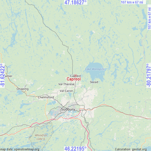
Capreol GPS coordinates[2]
46° 42' 22.536" North, 80° 55' 15.924" West
| Map corner | latitude | longitude |
|---|---|---|
| Upper-left | 47.18627°, | -81.62422° |
| Center: | 46.70626°, | -80.92109° |
| Lower-right: | 46.22195°, | -80.21797° |
| Map W x H: | 107.2×107.2 km | = 66.6×66.6mi |
| max Lat: | 73.03752° ⇑53.3% North |
| Capreol: | 46.70626° |
| min Lat: | ⇓46.7% South 42.05009° |
| min Long | Capreol | max Long |
| -139.43328° | -80.92109° | -52.70931° |
| W 41.6%⇐ | ⇒58.4% E |
Elevation
Elevation of Capreol is 308 m = 1010 ft, and this is 53.6 m = 176 ft above average elevation for this country.
| Max E: |
1518 m = 4980 ft | 29.5% |
| Capreol | 308 m 1010 ft | |
| Avg. | 254.4 m = 835 ft | |
Min E: |
-2 m = -7 ft | 70.5% |
See also: Canada elevation on elevation.city.
Geographical zone
Capreol is located in North temperate zone (between Tropic of Cancer and the Arctic Circle). Distance of this North polar circle is 2207.9 km =1371.9 mi to North.| Distance of | km | miles | from Capreol |
|---|---|---|---|
| North Pole | 4813.8 | 2991.2 | to North |
| Arctic Circle | 2207.9 | 1371.9 | to North |
| Tropic Cancer | 2587.3 | 1607.7 | to South |
| Equator | 5193.2 | 3226.9 | to South |


Nearby cities:
15 places around Capreol: (largest is in red/bold)
• Azilda
22.1 km =13.7 mi,  218°
218°
• Cache Bay
81.1 km =50.4 mi,  117°
117°
• Dowling
34.4 km =21.4 mi,  248°
248°
• Elliot Lake
135.8 km =84.4 mi, 254°
• Espanola
81.7 km =50.8 mi,  232°
232°
• Greater Sudbury
24.6 km =15.3 mi,  192°
192°
• Little Current
111.7 km =69.4 mi, 223°
• Lively
35 km =21.7 mi,  209°
209°
• North Bay
119.4 km =74.2 mi,  111°
111°
• Rayside-Balfour
24.4 km =15.2 mi,  243°
243°
• Spanish
123.1 km =76.5 mi, 242°
• Temiskaming Shores
126.5 km =78.6 mi,  46°
46°
• Témiscaming
139.1 km =86.4 mi,  89°
89°
• Valley East
7.4 km =4.6 mi, 234°
• Ville-Marie
132.6 km =82.4 mi,  58°
58°
Sources, notices
• [Note1] Compared only with cities in Canada existing in our database
• [Src1] Map data: © OpenStreetMap contributors (CC-BY-SA)
• [Src2] Other city data from geonames.org with taken over terms of usage.
• [Src3] Geographical zone / Annual Mean Temperature by Robert A. Rohde @ Wikipedia
