Macamic geodata
Macamic (Quebec) is a populated place; located in Canada in America/Toronto (GMT-4) time zone. With population of 1,559 people, there are 845 cities with bigger population in this country. Compared to other cities in Canada, 59.8% of cities are located further ↓South; 50.4% of cities are located further ←West and 68.5% of cities have lower elevation than Macamic. Note1


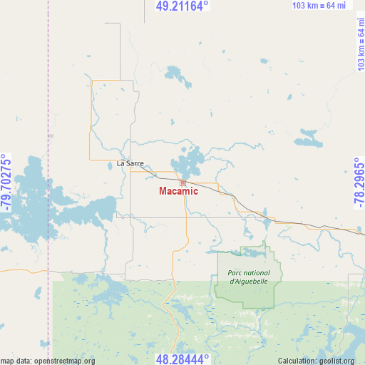
Macamic GPS coordinates[2]
48° 45' 0.648" North, 78° 59' 58.632" West
| Map corner | latitude | longitude |
|---|---|---|
| Upper-left | 49.21164°, | -79.70275° |
| Center: | 48.75018°, | -78.99962° |
| Lower-right: | 48.28444°, | -78.2965° |
| Map W x H: | 103.1×103.1 km | = 64.1×64.1mi |
| max Lat: | 73.03752° ⇑40.2% North |
| Macamic: | 48.75018° |
| min Lat: | ⇓59.8% South 42.05009° |
| min Long | Macamic | max Long |
| -139.43328° | -78.99962° | -52.70931° |
| W 50.4%⇐ | ⇒49.6% E |
Elevation
Elevation of Macamic is 283 m = 928 ft, and this is 28.6 m = 94 ft above average elevation for this country.
| Max E: |
1518 m = 4980 ft | 31.5% |
| Macamic | 283 m 928 ft | |
| Avg. | 254.4 m = 835 ft | |
Min E: |
-2 m = -7 ft | 68.5% |
See also: Canada elevation on elevation.city.
Geographical zone
Macamic is located in North temperate zone (between Tropic of Cancer and the Arctic Circle). Distance of this North polar circle is 1980.7 km =1230.7 mi to North.| Distance of | km | miles | from Macamic |
|---|---|---|---|
| North Pole | 4586.6 | 2850 | to North |
| Arctic Circle | 1980.7 | 1230.7 | to North |
| Tropic Cancer | 2814.6 | 1748.9 | to South |
| Equator | 5420.5 | 3368.1 | to South |


Nearby cities:
15 places around Macamic: (largest is in red/bold)
• Amos
68 km =42.3 mi,  107°
107°
• Barraute
106.5 km =66.2 mi, 109°
• Englehart
122 km =75.8 mi,  211°
211°
• Iroquois Falls
123.4 km =76.7 mi,  270°
270°
• Kirkland Lake
102 km =63.4 mi,  228°
228°
• La Sarre
15.7 km =9.8 mi,  290°
290°
• Lebel-sur-Quévillon
151.1 km =93.9 mi,  77°
77°
• Malartic
93.8 km =58.3 mi,  137°
137°
• Matagami
149 km =92.6 mi,  41°
41°
• Rouyn-Noranda
57.1 km =35.5 mi,  181°
181°
• Saint-Bruno-de-Guigues
146.3 km =90.9 mi,  192°
192°
• Saint-Isidore
148.1 km =92 mi, 188°
• Senneterre
135.4 km =84.1 mi, 107°
• Temiskaming Shores
149.5 km =92.9 mi,  200°
200°
• Val-d'Or
114.6 km =71.2 mi,  129°
129°
Sources, notices
• [Note1] Compared only with cities in Canada existing in our database
• [Src1] Map data: © OpenStreetMap contributors (CC-BY-SA)
• [Src2] Other city data from geonames.org with taken over terms of usage.
• [Src3] Geographical zone / Annual Mean Temperature by Robert A. Rohde @ Wikipedia
