Rouyn-Noranda geodata
Rouyn-Noranda (Quebec) is a populated place; located in Canada in America/Toronto (GMT-4) time zone. With population of 23,504 people, there are 170 cities with bigger population in this country. Compared to other cities in Canada, 55.6% of cities are located further ↓South; 50.3% of cities are located further ←West and 69.3% of cities have lower elevation than Rouyn-Noranda. Note1


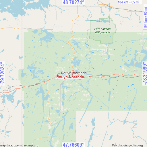
Rouyn-Noranda GPS coordinates[2]
48° 14' 11.616" North, 79° 1' 23.196" West
| Map corner | latitude | longitude |
|---|---|---|
| Upper-left | 48.70274°, | -79.72624° |
| Center: | 48.23656°, | -79.02311° |
| Lower-right: | 47.76609°, | -78.31999° |
| Map W x H: | 104.1×104.1 km | = 64.7×64.7mi |
| max Lat: | 73.03752° ⇑44.4% North |
| Rouyn-Noranda: | 48.23656° |
| min Lat: | ⇓55.6% South 42.05009° |
| min Long | Rouyn-Noranda | max Long |
| -139.43328° | -79.02311° | -52.70931° |
| W 50.3%⇐ | ⇒49.7% E |
Elevation
Elevation of Rouyn-Noranda is 299 m = 981 ft, and this is 44.6 m = 146 ft above average elevation for this country.
| Max E: |
1518 m = 4980 ft | 30.7% |
| Rouyn-Noranda | 299 m 981 ft | |
| Avg. | 254.4 m = 835 ft | |
Min E: |
-2 m = -7 ft | 69.3% |
See also: Canada elevation on elevation.city.
Geographical zone
Rouyn-Noranda is located in North temperate zone (between Tropic of Cancer and the Arctic Circle). Distance of this North polar circle is 2037.8 km =1266.2 mi to North.| Distance of | km | miles | from Rouyn-Noranda |
|---|---|---|---|
| North Pole | 4643.7 | 2885.5 | to North |
| Arctic Circle | 2037.8 | 1266.2 | to North |
| Tropic Cancer | 2757.5 | 1713.4 | to South |
| Equator | 5363.4 | 3332.7 | to South |


Nearby cities:
15 places around Rouyn-Noranda: (largest is in red/bold)
• Amos
76.4 km =47.5 mi,  61°
61°
• Barraute
105.1 km =65.3 mi,  77°
77°
• Englehart
78.2 km =48.6 mi,  233°
233°
• Iroquois Falls
135.8 km =84.4 mi,  295°
295°
• Kirkland Lake
75.9 km =47.2 mi,  262°
262°
• La Sarre
64 km =39.8 mi,  348°
348°
• Macamic
57.1 km =35.5 mi,  1°
1°
• Malartic
67 km =41.6 mi,  99°
99°
• Notre-Dame-du-Lac
165.3 km =102.7 mi,  180°
180°
• Saint-Bruno-de-Guigues
90.9 km =56.5 mi,  199°
199°
• Saint-Isidore
91.7 km =57 mi,  193°
193°
• Senneterre
133 km =82.6 mi, 82°
• Temiskaming Shores
97.4 km =60.5 mi,  212°
212°
• Val-d'Or
92.2 km =57.3 mi, 99°
• Ville-Marie
105 km =65.2 mi, 196°
Sources, notices
• [Note1] Compared only with cities in Canada existing in our database
• [Src1] Map data: © OpenStreetMap contributors (CC-BY-SA)
• [Src2] Other city data from geonames.org with taken over terms of usage.
• [Src3] Geographical zone / Annual Mean Temperature by Robert A. Rohde @ Wikipedia
