Sept-Îles geodata
Sept-Îles (Quebec) is a populated place; located in Canada in America/Toronto (GMT-4) time zone. With population of 22,582 people, there are 174 cities with bigger population in this country. Compared to other cities in Canada, 77.4% of cities are located further ↓South; 87.4% of cities are located further ←West and 97.3% of cities have higher elevation than Sept-Îles. Note1


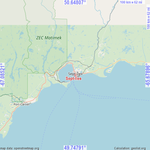
Sept-Îles GPS coordinates[2]
50° 12' 0.396" North, 66° 22' 55.488" West
| Map corner | latitude | longitude |
|---|---|---|
| Upper-left | 50.64807°, | -67.08521° |
| Center: | 50.20011°, | -66.38208° |
| Lower-right: | 49.74791°, | -65.67896° |
| Map W x H: | 100.1×100.1 km | = 62.2×62.2mi |
| max Lat: | 73.03752° ⇑22.6% North |
| Sept-Îles: | 50.20011° |
| min Lat: | ⇓77.4% South 42.05009° |
| min Long | Sept-Îles | max Long |
| -139.43328° | -66.38208° | -52.70931° |
| W 87.4%⇐ | ⇒12.6% E |
Elevation
Elevation of Sept-Îles is 5 m = 16 ft, and this is 249.4 m = 818 ft below average elevation for this country.
| Max E: |
1518 m = 4980 ft | 97.3% |
| Avg. | 254.4 m = 835 ft | |
| Sept-Îles | 5 m = 16 ft | |
Min E: |
-2 m = -7 ft | 2.7% |
See also: Canada elevation on elevation.city.
Geographical zone
Sept-Îles is located in North temperate zone (between Tropic of Cancer and the Arctic Circle). Distance of this North polar circle is 1819.4 km =1130.5 mi to North.| Distance of | km | miles | from Sept-Îles |
|---|---|---|---|
| North Pole | 4425.3 | 2749.8 | to North |
| Arctic Circle | 1819.4 | 1130.5 | to North |
| Tropic Cancer | 2975.8 | 1849.1 | to South |
| Equator | 5581.7 | 3468.3 | to South |


Nearby cities:
15 places around Sept-Îles: (largest is in red/bold)
• Amqui
207.5 km =128.9 mi,  201°
201°
• Baie-Comeau
167.6 km =104.1 mi,  229°
229°
• Cap-Chat
124.2 km =77.2 mi,  190°
190°
• Chute-aux-Outardes
188.6 km =117.2 mi, 230°
• Gaspé
204.7 km =127.2 mi,  137°
137°
• Godefroy
209.4 km =130.1 mi,  325°
325°
• Hauterive
175.1 km =108.8 mi, 230°
• Havre-Saint-Pierre
197.8 km =122.9 mi,  88°
88°
• Maliotenam
14.3 km =8.9 mi, 85°
• Matane
173.3 km =107.7 mi,  208°
208°
• Mont-Joli
222.4 km =138.2 mi,  216°
216°
• Murdochville
152 km =94.4 mi,  155°
155°
• Port-Cartier
39.1 km =24.3 mi,  241°
241°
• Saint-Alexandre
39.3 km =24.4 mi, 240°
• Sainte-Anne-des-Monts
119.9 km =74.5 mi,  183°
183°
Sources, notices
• [Note1] Compared only with cities in Canada existing in our database
• [Src1] Map data: © OpenStreetMap contributors (CC-BY-SA)
• [Src2] Other city data from geonames.org with taken over terms of usage.
• [Src3] Geographical zone / Annual Mean Temperature by Robert A. Rohde @ Wikipedia
