Maliotenam geodata
Maliotenam (Quebec) is a populated place; located in Canada in America/Toronto (GMT-4) time zone. With population of 1,316 people, there are 917 cities with bigger population in this country. Compared to other cities in Canada, 77.4% of cities are located further ↓South; 87.5% of cities are located further ←West and 71.5% of cities have higher elevation than Maliotenam. Note1


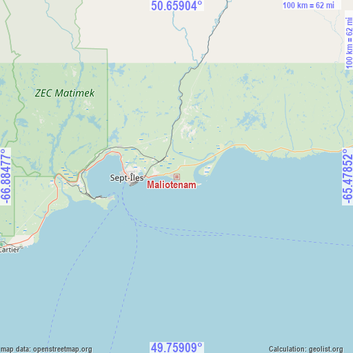
Maliotenam GPS coordinates[2]
50° 12' 40.284" North, 66° 10' 53.904" West
| Map corner | latitude | longitude |
|---|---|---|
| Upper-left | 50.65904°, | -66.88477° |
| Center: | 50.21119°, | -66.18164° |
| Lower-right: | 49.75909°, | -65.47852° |
| Map W x H: | 100.1×100.1 km | = 62.2×62.2mi |
| max Lat: | 73.03752° ⇑22.6% North |
| Maliotenam: | 50.21119° |
| min Lat: | ⇓77.4% South 42.05009° |
| min Long | Maliotenam | max Long |
| -139.43328° | -66.18164° | -52.70931° |
| W 87.5%⇐ | ⇒12.5% E |
Elevation
Elevation of Maliotenam is 51 m = 167 ft, and this is 203.4 m = 667 ft below average elevation for this country.
| Max E: |
1518 m = 4980 ft | 71.5% |
| Avg. | 254.4 m = 835 ft | |
| Maliotenam | 51 m = 167 ft | |
Min E: |
-2 m = -7 ft | 28.5% |
See also: Canada elevation on elevation.city.
Geographical zone
Maliotenam is located in North temperate zone (between Tropic of Cancer and the Arctic Circle). Distance of this North polar circle is 1818.2 km =1129.8 mi to North.| Distance of | km | miles | from Maliotenam |
|---|---|---|---|
| North Pole | 4424.1 | 2749 | to North |
| Arctic Circle | 1818.2 | 1129.8 | to North |
| Tropic Cancer | 2977 | 1849.8 | to South |
| Equator | 5583 | 3469.1 | to South |


Nearby cities:
15 places around Maliotenam: (largest is in red/bold)
• Amqui
214.3 km =133.2 mi,  204°
204°
• Baie-Comeau
179.5 km =111.5 mi,  231°
231°
• Cap-Chat
128.7 km =80 mi, 196°
• Chute-aux-Outardes
200.7 km =124.7 mi, 232°
• Gaspé
196.3 km =122 mi,  141°
141°
• Godefroy
216.7 km =134.7 mi,  322°
322°
• Hauterive
187.2 km =116.3 mi, 232°
• Havre-Saint-Pierre
183.5 km =114 mi,  88°
88°
• Maria
226.9 km =141 mi,  176°
176°
• Matane
181.6 km =112.8 mi,  212°
212°
• Murdochville
147.7 km =91.8 mi,  160°
160°
• Port-Cartier
52.6 km =32.7 mi,  247°
247°
• Saint-Alexandre
52.7 km =32.7 mi, 246°
• Sainte-Anne-des-Monts
122.9 km =76.4 mi,  190°
190°
• Sept-Îles
14.3 km =8.9 mi,  265°
265°
Sources, notices
• [Note1] Compared only with cities in Canada existing in our database
• [Src1] Map data: © OpenStreetMap contributors (CC-BY-SA)
• [Src2] Other city data from geonames.org with taken over terms of usage.
• [Src3] Geographical zone / Annual Mean Temperature by Robert A. Rohde @ Wikipedia
